


lp40_MEES Tourbieres le tour

GR77LP
User
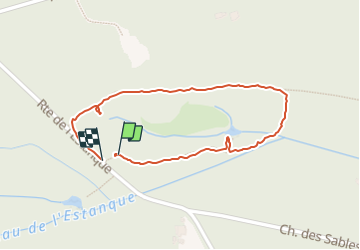

Length
949 m

Max alt
36 m

Uphill gradient
7 m
Km-Effort
1 km

Min alt
28 m

Downhill gradient
6 m
Boucle
Yes
Creation date :
2022-02-20 13:47:04.019
Updated on :
2022-02-20 14:11:56.175
24m
Difficulty : Very easy

FREE GPS app for hiking
 SityTrail
IGN / Geographical institutes
SityTrail Plus
The world is yours!
About
Trail Walking of 949 m to be discovered at New Aquitaine, Landes, Mées. This trail is proposed by GR77LP.
Photos


Positioning
Country:
France
Region :
New Aquitaine
Department/Province :
Landes
Municipality :
Mées
Location:
Unknown
Start:(Dec)
Start:(UTM)
651004 ; 4840774 (30T) N.
Comments