


Riviere Massane fev 22

patbt
User
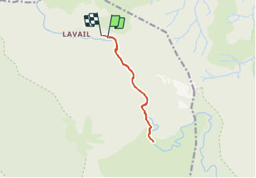

Length
5.8 km

Max alt
426 m

Uphill gradient
186 m
Km-Effort
8.3 km

Min alt
232 m

Downhill gradient
186 m
Boucle
Yes
Creation date :
2022-02-20 11:05:35.629
Updated on :
2022-02-25 07:38:02.508
4h08
Difficulty : Very easy

FREE GPS app for hiking
 SityTrail
IGN / Geographical institutes
SityTrail Plus
The world is yours!
About
Trail Walking of 5.8 km to be discovered at Occitania, Pyrénées-Orientales, Sorède. This trail is proposed by patbt.
Positioning
Country:
France
Region :
Occitania
Department/Province :
Pyrénées-Orientales
Municipality :
Sorède
Location:
Unknown
Start:(Dec)
Start:(UTM)
500457 ; 4706112 (31T) N.
Comments