Trail Walking Les Monts d'Aunay - 2022-02-25 balade nous samy  danvou la ferrière gîte - Photo

2022-02-25 balade nous samy danvou la ferrière gîte

© OpenStreetMap contributors
Length
Length
5.3 km
Max alt
Max alt
244 m
Uphill gradient
Uphill gradient
101 m
Km-Effort
Km-Effort  
6.6 km
Min alt
Min alt
191 m
Downhill gradient
Downhill gradient
100 m
Boucle
Boucle
Yes
Creation date :
2022-02-25 15:22:52.324
Updated on :
2022-02-25 17:06:12.77

(0 Reviews)

Walking
Walking
1h29
Difficulty : Easy

Scan this QR Code to open this trail in the SityTrail application

FREE GPS app for hiking

Logo SityTrail SityTrail

IGN / Geographical institutes

Download SityTrail from the App Store Download SityTrail from Google Play

Logo SityTrail SityTrail World

The world is yours!

Download SityTrail from the App Store Download SityTrail from Google Play Download SityTrail on Huawei AppGallery

About

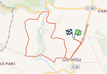
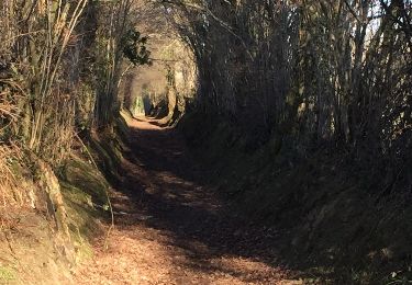
Trail Walking of 5.3 km to be discovered at Normandy, Calvados, Les Monts d'Aunay. This trail is proposed by rolandmonjean.

Description

2022-02-25 balade nous samy  danvou la ferrière gîte

Elevation profile

Photos

Positioning

Country:
France
Region :
Normandy
Department/Province :
Calvados
Municipality :
Les Monts d'Aunay
Location:
Unknown
Start:(UTM)
670376 ; 5425466 (30U) N.

Trails nearby

Trail Walking Les Monts d'Aunay - mt pincon trois monts - Photo
Walking
albers

Walking

Difficult
Les Monts d'Aunay, Normandy, Calvados, France
29 km | 36 km-effort
6h 0min
No
Trail On foot Les Monts d'Aunay - Le Mont Pinçon - Photo
On foot
GUIDE+

On foot

Easy
Les Monts d'Aunay, Normandy, Calvados, France
8.2 km | 10.2 km-effort
2h 18min
Yes
Trail Walking Souleuvre-en-Bocage - Montchauvet Calvados - Photo
Walking
Roulland

Walking

Easy
Souleuvre-en-Bocage, Normandy, Calvados, France
18.2 km | 22 km-effort
5h 37min
Yes
Trail Walking Les Monts d'Aunay - ROUCAMPS  2 - Photo
Walking
lensois

Walking

Difficult
Les Monts d'Aunay, Normandy, Calvados, France
8.7 km | 11.2 km-effort
2h 52min
Yes
Trail On foot Les Monts d'Aunay - Les Ferrières de Danvou - Photo
On foot
GUIDE+

On foot

Easy
Les Monts d'Aunay, Normandy, Calvados, France
6.4 km | 7.8 km-effort
1h 46min
No
Trail On foot Condé-en-Normandie - Chemins Creux D - Photo
On foot
GUIDE+

On foot

Easy
Condé-en-Normandie, Normandy, Calvados, France
6.9 km | 8.6 km-effort
1h 56min
Yes
Trail On foot Terres de Druance - Le Ruisseau des Vaux - Photo
On foot
GUIDE+

On foot

Easy
Terres de Druance, Normandy, Calvados, France
10.4 km | 13.4 km-effort
3h 2min
Yes
Trail On foot Les Monts d'Aunay - Les Hauts de Roucamps - Photo
On foot
GUIDE+

On foot

Easy
Les Monts d'Aunay, Normandy, Calvados, France
8.1 km | 9.7 km-effort
2h 12min
No
Trail Walking Les Monts d'Aunay - pression grimoult - Photo
Walking
arnaudconde

Walking

Medium
Les Monts d'Aunay, Normandy, Calvados, France
9.5 km | 11.6 km-effort
2h 42min
Yes


Close
My subscriptions