Trail Walking Bex - Bex (Genferseegebiet) - Photo

Bex (Genferseegebiet)

Optez pour le retour à la nature GUIDE+

© OpenStreetMap contributors
Length
Length
10.5 km
Max alt
Max alt
1667 m
Uphill gradient
Uphill gradient
603 m
Km-Effort
Km-Effort  
18.6 km
Min alt
Min alt
1071 m
Downhill gradient
Downhill gradient
614 m
Boucle
Boucle
Yes
Creation date :
2014-12-10 00:00:00.0
Updated on :
2014-12-10 00:00:00.0

(0 Reviews)

Walking
Walking
5h55
Difficulty : Unknown

Scan this QR Code to open this trail in the SityTrail application

FREE GPS app for hiking

Logo SityTrail SityTrail

IGN / Geographical institutes

Download SityTrail from the App Store Download SityTrail from Google Play

Logo SityTrail SityTrail World

The world is yours!

Download SityTrail from the App Store Download SityTrail from Google Play Download SityTrail on Huawei AppGallery

About

Trail Walking of 10.5 km to be discovered at Vaud, District d'Aigle, Bex. This trail is proposed by My Switzerland.

Description

Gleich nach Pont-de-Nant liegt der Alpengarten «Thomasia». Der Alpengarten wurde von der Familie Thomas 1891 angelegt. Dem Avançon entlang geht''s anschliessend hinauf zur Holzbrücke. Nach dem schmalen Weg durchs Unterholz wartet mit dem «Trou à l''Ours», zu deutsch Bärenloch, ein nächstes Highlight auf die Wanderer. Hier ist Trittsicherheit gefragt. Via Cinglo führt der Weg zurück hinunter nach Les Plans-sur-Bex.


Besonderes Erlebnis: Die Salzminen von Bex

Spannende Führung durch das Salzbergwerk Le Bouillet beim waadtländischen Bex. Der Rundgang in diesem riesigen unterirdischen Labyrinth offenbart die spektakulären und die eigentümlichen Aspekte der Abbautechniken, die seit dem Bau des ersten Stollens im Jahre 1684 bis heute angewandt werden.

Elevation profile

Positioning

Country:
Switzerland
Region :
Vaud
Department/Province :
District d'Aigle
Municipality :
Bex
Location:
Unknown
Start:(UTM)
354389 ; 5123788 (32T) N.

Trails nearby

Trail Walking Bex - Tour du miroir d'Argentine - Photo
Walking
perenhout

Walking

Very difficult
Bex, Vaud, District d'Aigle, Switzerland
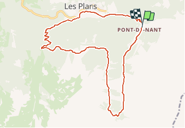
16.8 km | 30 km-effort
7h 5min
Yes
Trail Walking Ollon - st_bg_villars1 - Photo
Walking
GUIDE+

Walking

Very easy
Ollon, Vaud, District d'Aigle, Switzerland
5.6 km | 8.3 km-effort
Unknown
No
Trail Mountain bike Ollon - Bike32918 - Photo
Mountain bike
GUIDE+

Mountain bike

Very easy
Ollon, Vaud, District d'Aigle, Switzerland
22 km | 35 km-effort
Unknown
Yes
Trail Running Gryon - Mxalps - Photo
Running
gut72ch

Running

Difficult
Gryon, Vaud, District d'Aigle, Switzerland
61 km | 116 km-effort
10h 0min
No
Trail Running Gryon - Mxalps - Photo
Running
gut72ch

Running

Difficult
Gryon, Vaud, District d'Aigle, Switzerland
61 km | 116 km-effort
Unknown
No
Trail Walking Lavey-Morcles - Morcles, Pointe des Martinets - Photo
Walking
rpf

Walking

Very easy
Lavey-Morcles, Vaud, District d'Aigle, Switzerland
9.4 km | 22 km-effort
6h 30min
Yes
Trail Walking Chamoson - Ovronnaz, Les Pointes de Tsérié - Photo
Walking
rpf

Walking

Very easy
Chamoson, Valais/Wallis, Conthey, Switzerland
10.2 km | 23 km-effort
7h 30min
Yes
Trail Walking Chamoson - Ovronnaz, Dent de Chamosentze - Photo
Walking
rpf

Walking

Very easy
Chamoson, Valais/Wallis, Conthey, Switzerland
6.9 km | 15.4 km-effort
4h 30min
Yes
Trail Walking Chamoson - Ovronnaz, Tita Naire - Photo
Walking
rpf

Walking

Very easy
Chamoson, Valais/Wallis, Conthey, Switzerland
11.4 km | 22 km-effort
6h 30min
Yes


Close
My subscriptions