


flassa. taratera 850 positif 13km 4h30

Erius
User
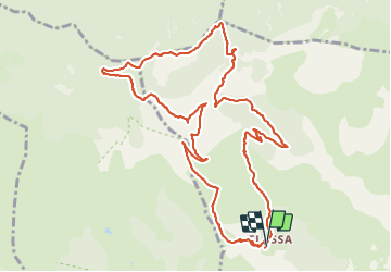

Length
13.8 km

Max alt
1797 m

Uphill gradient
850 m
Km-Effort
25 km

Min alt
966 m

Downhill gradient
858 m
Boucle
Yes
Creation date :
2022-02-27 08:29:56.48
Updated on :
2022-03-01 09:31:04.044
4h21
Difficulty : Very difficult

FREE GPS app for hiking
 SityTrail
IGN / Geographical institutes
SityTrail Plus
The world is yours!
About
Trail Walking of 13.8 km to be discovered at Occitania, Pyrénées-Orientales, Serdinya. This trail is proposed by Erius.
Description
départ eglisette après piste carrossable auto haute
Photos


Positioning
Country:
France
Region :
Occitania
Department/Province :
Pyrénées-Orientales
Municipality :
Serdinya
Location:
Unknown
Start:(Dec)
Start:(UTM)
443645 ; 4713824 (31T) N.
Comments