


Peisey 4

phugues
User
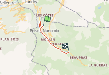

Length
5.9 km

Max alt
1485 m

Uphill gradient
345 m
Km-Effort
9.9 km

Min alt
1160 m

Downhill gradient
169 m
Boucle
No
Creation date :
2022-03-01 16:06:58.051
Updated on :
2022-03-03 19:51:05.463
1h45
Difficulty : Medium

FREE GPS app for hiking
 SityTrail
IGN / Geographical institutes
SityTrail Plus
The world is yours!
About
Trail Walking of 5.9 km to be discovered at Auvergne-Rhône-Alpes, Savoy, Peisey-Nancroix. This trail is proposed by phugues.
Positioning
Country:
France
Region :
Auvergne-Rhône-Alpes
Department/Province :
Savoy
Municipality :
Peisey-Nancroix
Location:
Unknown
Start:(Dec)
Start:(UTM)
324687 ; 5046564 (32T) N.
Comments