Trail Mountain bike Ormont-Dessus - Bike32917 - Photo

Optez pour le retour à la nature GUIDE+

© OpenStreetMap contributors
Length
Length
15.6 km
Max alt
Max alt
1731 m
Uphill gradient
Uphill gradient
610 m
Km-Effort
Km-Effort  
24 km
Min alt
Min alt
1153 m
Downhill gradient
Downhill gradient
607 m
Boucle
Boucle
Yes
Creation date :
2014-12-10 00:00:00.0
Updated on :
2014-12-10 00:00:00.0

(0 Reviews)

Mountain bike
Mountain bike
--
Difficulty : Unknown

Scan this QR Code to open this trail in the SityTrail application

FREE GPS app for hiking

Logo SityTrail SityTrail

IGN / Geographical institutes

Download SityTrail from the App Store Download SityTrail from Google Play

Logo SityTrail SityTrail World

The world is yours!

Download SityTrail from the App Store Download SityTrail from Google Play Download SityTrail on Huawei AppGallery

About

Trail Mountain bike of 15.6 km to be discovered at Vaud, District d'Aigle, Ormont-Dessus. This trail is proposed by My Switzerland.

Elevation profile

Points of interest

Point of interest Ormont-Dessus - Bahnhof Les Diablerets - Photo
My Switzerland
ORMONT-DESSUS 
Point of interest Ormont-Dessus - Bahnhof Les Diablerets - Photo
My Switzerland
ORMONT-DESSUS 
Point of interest Ormont-Dessus -  - Photo
My Switzerland
ORMONT-DESSUS 
Point of interest Ormont-Dessus - Lac Retaud - Photo
My Switzerland
ORMONT-DESSUS 

Positioning

Country:
Switzerland
Region :
Vaud
Department/Province :
District d'Aigle
Municipality :
Ormont-Dessus
Location:
Unknown
Start:(UTM)
358058 ; 5134730 (32T) N.

Trails nearby

Trail Walking Ormont-Dessus - Glacier3000 - Sanetsch - Photo
Walking
GUIDE+

Walking

Very easy
Ormont-Dessus, Vaud, District d'Aigle, Switzerland
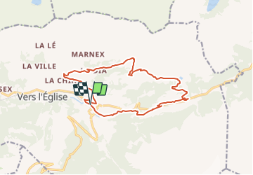
19.8 km | 43 km-effort
Unknown
No
Trail Walking Ormont-Dessus - w10_24_diable - Photo
Walking
GUIDE+

Walking

Very easy
Ormont-Dessus, Vaud, District d'Aigle, Switzerland
12.9 km | 17.3 km-effort
3h 38min
No
Trail Running Ormont-Dessus - Humani'Trail_2022_27km_-_by_betrail - Photo
Running
Doubotis

Running

Ormont-Dessus, Vaud, District d'Aigle, Switzerland
27 km | 47 km-effort
Unknown
Yes
Trail Walking Ormont-Dessous - Lac Lioson - Photo
Walking
mallovon

Walking

Very easy
Ormont-Dessous, Vaud, District d'Aigle, Switzerland
7.8 km | 14.7 km-effort
4h 24min
Yes
Trail Walking Ollon - Circuit Col de la Croix - les lacs - Bretaye 13.07.17 - Photo
Walking
duamerg

Walking

Medium
Ollon, Vaud, District d'Aigle, Switzerland
13.8 km | 21 km-effort
4h 27min
Yes
Trail Walking Ormont-Dessous - Col des Mosses - Lac Lioson - Pra Cornet - Photo
Walking
duamerg

Walking

Medium
Ormont-Dessous, Vaud, District d'Aigle, Switzerland
9.6 km | 16 km-effort
3h 22min
Yes
Trail Walking Ormont-Dessus - Blattipass - Photo
Walking
danihz

Walking

Medium
Ormont-Dessus, Vaud, District d'Aigle, Switzerland
11.5 km | 20 km-effort
3h 58min
No
Trail Walking Ollon - Col de la Croix - Photo
Walking
danihz

Walking

Medium
Ollon, Vaud, District d'Aigle, Switzerland
11.9 km | 18.1 km-effort
3h 51min
Yes
Trail Other activity Ormont-Dessus - refuge de Pierredar  - Photo
Other activity
paul74

Other activity

Difficult
Ormont-Dessus, Vaud, District d'Aigle, Switzerland
14.2 km | 30 km-effort
9h 2min
Yes


Close
My subscriptions