


TOP84

aldaus
User

Length
26 km

Max alt
1910 m

Uphill gradient
1696 m
Km-Effort
49 km

Min alt
429 m

Downhill gradient
1701 m
Boucle
Yes
Creation date :
2022-03-02 05:59:05.486
Updated on :
2023-03-21 18:56:52.27
9h03
Difficulty : Medium

FREE GPS app for hiking
 SityTrail
IGN / Geographical institutes
SityTrail Plus
The world is yours!
About
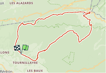
Trail Walking of 26 km to be discovered at Provence-Alpes-Côte d'Azur, Vaucluse, Bédoin. This trail is proposed by aldaus.
Positioning
Country:
France
Region :
Provence-Alpes-Côte d'Azur
Department/Province :
Vaucluse
Municipality :
Bédoin
Location:
Unknown
Start:(Dec)
Start:(UTM)
675856 ; 4889621 (31T) N.
Comments