


col de la chal

phugues
User
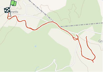

Length
3.7 km

Max alt
2546 m

Uphill gradient
113 m
Km-Effort
5.3 km

Min alt
2461 m

Downhill gradient
121 m
Boucle
Yes
Creation date :
2022-03-03 12:40:14.992
Updated on :
2022-03-03 14:01:04.356
1h20
Difficulty : Easy

FREE GPS app for hiking
 SityTrail
IGN / Geographical institutes
SityTrail Plus
The world is yours!
About
Trail Walking of 3.7 km to be discovered at Auvergne-Rhône-Alpes, Savoy, Peisey-Nancroix. This trail is proposed by phugues.
Positioning
Country:
France
Region :
Auvergne-Rhône-Alpes
Department/Province :
Savoy
Municipality :
Peisey-Nancroix
Location:
Unknown
Start:(Dec)
Start:(UTM)
329078 ; 5046464 (32T) N.
Comments