


Vallée Blanche

jcolonnadelega
User
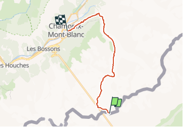

Length
19.6 km

Max alt
3432 m

Uphill gradient
41 m
Km-Effort
28 km

Min alt
1044 m

Downhill gradient
2420 m
Boucle
No
Creation date :
2022-03-03 09:17:55.753
Updated on :
2022-03-10 18:25:41.558
5h19
Difficulty : Very easy

FREE GPS app for hiking
 SityTrail
IGN / Geographical institutes
SityTrail Plus
The world is yours!
About
Trail Touring skiing of 19.6 km to be discovered at Aosta Valley, Unknown, Courmayeur. This trail is proposed by jcolonnadelega.
Positioning
Country:
Italy
Region :
Aosta Valley
Department/Province :
Unknown
Municipality :
Courmayeur
Location:
Unknown
Start:(Dec)
Start:(UTM)
339400 ; 5079001 (32T) N.
Comments