


L epinerie

phugues
User
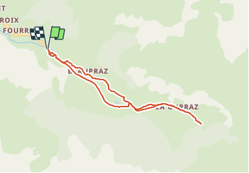

Length
7.5 km

Max alt
1667 m

Uphill gradient
179 m
Km-Effort
9.9 km

Min alt
1477 m

Downhill gradient
180 m
Boucle
Yes
Creation date :
2022-03-04 08:41:08.015
Updated on :
2022-03-04 10:09:46.982
1h28
Difficulty : Medium

FREE GPS app for hiking
 SityTrail
IGN / Geographical institutes
SityTrail Plus
The world is yours!
About
Trail Walking of 7.5 km to be discovered at Auvergne-Rhône-Alpes, Savoy, Peisey-Nancroix. This trail is proposed by phugues.
Positioning
Country:
France
Region :
Auvergne-Rhône-Alpes
Department/Province :
Savoy
Municipality :
Peisey-Nancroix
Location:
Unknown
Start:(Dec)
Start:(UTM)
326956 ; 5044078 (32T) N.
Comments