


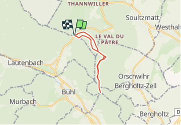
col de bannstein dreibannstein

baratta
User

Length
8.6 km

Max alt
574 m

Uphill gradient
198 m
Km-Effort
11.2 km

Min alt
489 m

Downhill gradient
200 m
Boucle
Yes
Creation date :
2022-03-10 10:04:50.747
Updated on :
2022-03-10 10:07:54.979
2h32
Difficulty : Easy

FREE GPS app for hiking
 SityTrail
IGN / Geographical institutes
SityTrail Plus
The world is yours!
About
Trail Walking of 8.6 km to be discovered at Grand Est, Haut-Rhin, Soultzmatt. This trail is proposed by baratta.
Positioning
Country:
France
Region :
Grand Est
Department/Province :
Haut-Rhin
Municipality :
Soultzmatt
Location:
Unknown
Start:(Dec)
Start:(UTM)
365065 ; 5312739 (32T) N.
Comments