


Val Thorens

GOHIER
User
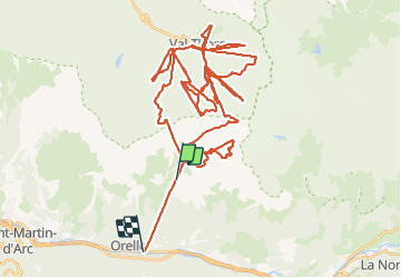

Length
80 km

Max alt
3215 m

Uphill gradient
7859 m
Km-Effort
189 km

Min alt
871 m

Downhill gradient
9293 m
Boucle
No
Creation date :
2022-03-10 08:33:03.0
Updated on :
2022-03-10 16:07:43.665
7h32
Difficulty : Very easy

FREE GPS app for hiking
 SityTrail
IGN / Geographical institutes
SityTrail Plus
The world is yours!
About
Trail Alpine skiing of 80 km to be discovered at Auvergne-Rhône-Alpes, Savoy, Orelle. This trail is proposed by GOHIER.
Description
Avec Patou. Magnifique journée de ski, neige parfaite 🤩
Positioning
Country:
France
Region :
Auvergne-Rhône-Alpes
Department/Province :
Savoy
Municipality :
Orelle
Location:
Unknown
Start:(Dec)
Start:(UTM)
308898 ; 5012324 (32T) N.
Comments