Trail Walking Basse-Terre - Volcano Trail 2010 - La Rando - Photo

Volcano Trail 2010 - La Rando

 tracegps
tracegps

User

© OpenStreetMap contributors
Length
Length
27 km
Max alt
Max alt
1206 m
Uphill gradient
Uphill gradient
1773 m
Km-Effort
Km-Effort  
49 km
Min alt
Min alt
5 m
Downhill gradient
Downhill gradient
1303 m
Boucle
Boucle
No
Creation date :
2016-03-09 00:00:00.0
Updated on :
2016-03-09 00:00:00.0

(0 Reviews)

Walking
Walking
6h10
Difficulty : Very difficult

Scan this QR Code to open this trail in the SityTrail application

FREE GPS app for hiking

Logo SityTrail SityTrail

IGN / Geographical institutes

Download SityTrail from the App Store Download SityTrail from Google Play

Logo SityTrail SityTrail World

The world is yours!

Download SityTrail from the App Store Download SityTrail from Google Play Download SityTrail on Huawei AppGallery

About

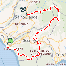
Trail Walking of 27 km to be discovered at Guadeloupe, Unknown, Basse-Terre. This trail is proposed by tracegps.

Description

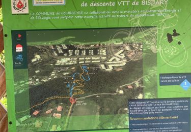
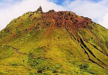
Ce parcours est commun avec le Grand Raid sur les 17 premiers kilomètres. Vous parcourez les Monts Caraïbes, remontez la rivière du Galion, gravissez la terrible trace des Poteaux et finissez à St Claude. Là aussi vous alternez les milieux tropicaux, de la forêt du bord de mer dans les Monts Caraïbes aux savanes d'altitudes. (Source organisateur Altitudes Tropicales). Temps record de 3H43. L’auteur de la trace (Delphine) l’a bouclé en 6h14.

Elevation profile

Photos

Positioning

Country:
France
Region :
Guadeloupe
Department/Province :
Unknown
Municipality :
Basse-Terre
Location:
Unknown
Start:(UTM)
636582 ; 1767958 (20P) N.

Trails nearby

Trail Trail Saint-Claude - Beausoleil la boucle  - Photo
Trail
sameja

Trail

Difficult
Saint-Claude, Guadeloupe, Unknown, France
13.5 km | 25 km-effort
2h 11min
Yes
Trail Running Saint-Claude - St Claude  - Photo
Running
sameja

Running

Medium
Saint-Claude, Guadeloupe, Unknown, France
6.9 km | 12 km-effort
1h 2min
Yes
Trail Trail Saint-Claude - Beausoleil  - Photo
Trail
sameja

Trail

Very difficult
Saint-Claude, Guadeloupe, Unknown, France
13.6 km | 27 km-effort
4h 5min
Yes
Trail Nordic walking Gourbeyre - Centre volcanologique  - Photo
Nordic walking
sameja

Nordic walking

Medium
Gourbeyre, Guadeloupe, Unknown, France
6.5 km | 11.5 km-effort
1h 45min
Yes
Trail Trail Gourbeyre - Houėlmont observatoire volcanologique  - Photo
Trail
sameja

Trail

Difficult
Gourbeyre, Guadeloupe, Unknown, France
6.4 km | 11.5 km-effort
1h 22min
Yes
Trail Trail Gourbeyre - Gourbeyre - Photo
Trail
sameja

Trail

Difficult
Gourbeyre, Guadeloupe, Unknown, France
17.1 km | 27 km-effort
2h 10min
Yes
Trail Walking Saint-Claude - Soufrière - Photo
Walking
GUIDE
manuelPerez

Walking

Saint-Claude, Guadeloupe, Unknown, France
12.5 km | 21 km-effort
2h 46min
No
Trail Running Basse-Terre - Volcano Trail - Grand Raid de la Région Guadeloupe - Édition 2009 - Photo
Running
tracegps

Running

Very difficult
Basse-Terre, Guadeloupe, Unknown, France
44 km | 86 km-effort
11h 30min
No
Trail Walking Gourbeyre - reco exam poudriere - Photo
Walking
ThereseH

Walking

Medium
Gourbeyre, Guadeloupe, Unknown, France
5.5 km | 9.4 km-effort
2h 37min
Yes


Close
My subscriptions