Trail Walking Esparron - Rocher de Saint-Pierre - Photo
© OpenStreetMap contributors
Length
Length
6.8 km
Max alt
Max alt
1423 m
Uphill gradient
Uphill gradient
465 m
Km-Effort
Km-Effort  
13 km
Min alt
Min alt
968 m
Downhill gradient
Downhill gradient
466 m
Boucle
Boucle
Yes
Creation date :
2022-03-15 08:26:16.045
Updated on :
2022-03-16 15:16:10.99

(0 Reviews)

Walking
Walking
4h06
Difficulty : Medium

Scan this QR Code to open this trail in the SityTrail application

FREE GPS app for hiking

Logo SityTrail SityTrail

IGN / Geographical institutes

Download SityTrail from the App Store Download SityTrail from Google Play

Logo SityTrail SityTrail World

The world is yours!

Download SityTrail from the App Store Download SityTrail from Google Play Download SityTrail on Huawei AppGallery

About

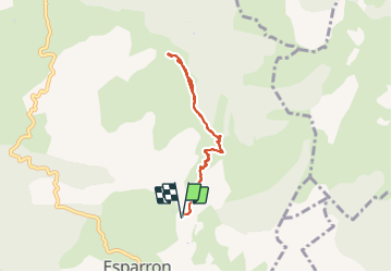
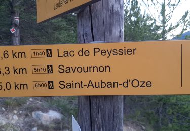
Trail Walking of 6.8 km to be discovered at Provence-Alpes-Côte d'Azur, Hautes-Alpes, Esparron. This trail is proposed by PapouBertrand.

Description

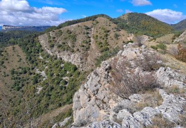
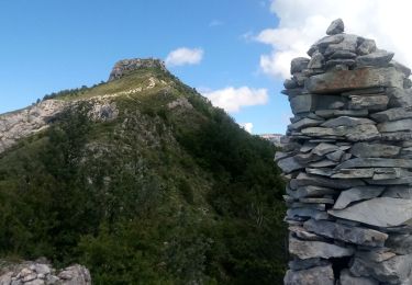
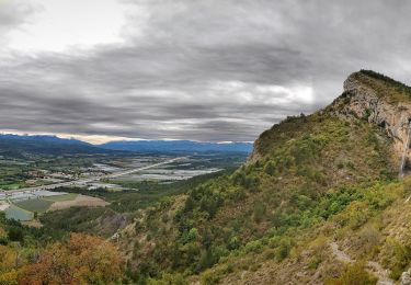
Rocher de Saint-Pierre via Esparron. Pour éviter les broussailles,  prendre à gauche avant le col de la Baume (versant Ouest) puis prendre versant Est à partir de la chapelle St-Pierre.

Elevation profile

Photos

Positioning

Country:
France
Region :
Provence-Alpes-Côte d'Azur
Department/Province :
Hautes-Alpes
Municipality :
Esparron
Location:
Unknown
Start:(UTM)
731495 ; 4926973 (31T) N.

Trails nearby

Trail Running Saint-Auban-d'Oze - Trail 01 - Le Cirque de Villauret - Photo
Running
GUIDE+

Running

Difficult
Saint-Auban-d'Oze, Provence-Alpes-Côte d'Azur, Hautes-Alpes, France
9.6 km | 19.9 km-effort
2h 0min
Yes
Trail Trail Châteauneuf-d'Oze - Tour et sommet petite Céüse - Photo
Trail
nadd73

Trail

Medium
Châteauneuf-d'Oze, Provence-Alpes-Côte d'Azur, Hautes-Alpes, France
11.8 km | 22 km-effort
2h 10min
Yes
Trail Walking Sigoyer - corniche de Ceüze tour - Photo
Walking
nadd73

Walking

Medium
Sigoyer, Provence-Alpes-Côte d'Azur, Hautes-Alpes, France
15.7 km | 28 km-effort
4h 13min
Yes
Trail Walking Vitrolles - Pic de Crigne - Photo
Walking
Marco05

Walking

Medium
Vitrolles, Provence-Alpes-Côte d'Azur, Hautes-Alpes, France
5.9 km | 14.3 km-effort
3h 14min
Yes
Trail Walking Sigoyer - Petite Ceüze - Photo
Walking
Marco05

Walking

Medium
Sigoyer, Provence-Alpes-Côte d'Azur, Hautes-Alpes, France
11.6 km | 22 km-effort
4h 54min
Yes
Trail Walking Vitrolles - Pic de Crigne - Photo
Walking
PapouBertrand

Walking

Very difficult
Vitrolles, Provence-Alpes-Côte d'Azur, Hautes-Alpes, France
11.6 km | 21 km-effort
5h 33min
No
Trail Walking Sigoyer - Montee de la petite Ceüz - Photo
Walking
tyax93

Walking

Easy
Sigoyer, Provence-Alpes-Côte d'Azur, Hautes-Alpes, France
3 km | 6.8 km-effort
1h 27min
No
Trail Walking Esparron - Montagne de Rochefort via Esparron - Photo
Walking
PapouBertrand

Walking

Very difficult
Esparron, Provence-Alpes-Côte d'Azur, Hautes-Alpes, France
12.6 km | 24 km-effort
6h 12min
Yes
Trail Walking Esparron - ESPARON 05 . Lac de Peyssier . Col de  Peyssier o s - Photo
Walking
RobinMicheline

Walking

Difficult
Esparron, Provence-Alpes-Côte d'Azur, Hautes-Alpes, France
15.9 km | 25 km-effort
4h 38min
Yes


Close
My subscriptions