Trail Walking Rémilly - Remilly et le Haut de Saint-Pierre - Photo

Remilly et le Haut de Saint-Pierre

 tracegps
tracegps

User

© OpenStreetMap contributors
Length
Length
21 km
Max alt
Max alt
325 m
Uphill gradient
Uphill gradient
290 m
Km-Effort
Km-Effort  
25 km
Min alt
Min alt
216 m
Downhill gradient
Downhill gradient
290 m
Boucle
Boucle
Yes
Creation date :
2014-12-10 00:00:00.0
Updated on :
2014-12-10 00:00:00.0

(0 Reviews)

Walking
Walking
5h30
Difficulty : Medium

Scan this QR Code to open this trail in the SityTrail application

FREE GPS app for hiking

Logo SityTrail SityTrail

IGN / Geographical institutes

Download SityTrail from the App Store Download SityTrail from Google Play

Logo SityTrail SityTrail World

The world is yours!

Download SityTrail from the App Store Download SityTrail from Google Play Download SityTrail on Huawei AppGallery

About

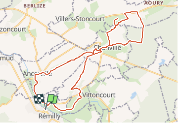
Trail Walking of 21 km to be discovered at Grand Est, Moselle, Rémilly. This trail is proposed by tracegps.

Description

Quitter la gare de Rémilly, traverser le passage à niveau sur la route D199b et la suivre sur 500 m. Quitter la route et partir à droite vers Voimhaut. Traverser ce village, puis monter à gauche à travers un petit bois. Arrivé en haut, tourner à droite et continuer vers le village de Chanville. À la sortie du village, emprunter la route forestière du Haut de Saint Pierre jusqu'au carrefour de la "Chapelle de la Vierge". Partir à gauche sur la route forestière de la Vierge qui débouche en lisière de la forêt. Continuer jusqu'à la D75, la suivre sur la gauche sur environ 650 m. Partir à gauche sur un chemin qui monte vers la butte du Haut de Saint Pierre. Beau panorama, croix de Lorraine érigée par les anciens de la 2ème DB, chapelle et cimetière du 3ème siècle. Redescendre par le même chemin, balisé anneau vert emprunté à la montée, avant de se diriger vers Chanville. À la sortie du village, tourner à droite sur D70 sur 200 m. Puis monter à gauche sur un chemin agricole. Rejoindre Ancerville que l'on traverse. À la sortie du village, voir le château et rejoindre la gare de Rémilly en longeant la Nied Française.

Elevation profile

Photos

Positioning

Country:
France
Region :
Grand Est
Department/Province :
Moselle
Municipality :
Rémilly
Location:
Unknown
Start:(UTM)
309439 ; 5432325 (32U) N.

Trails nearby

Trail On foot Hémilly - Circuit de Chanville - Haut St Pierre - Photo
On foot
PRO

On foot

Easy
Hémilly, Grand Est, Moselle, France
3.3 km | 4.2 km-effort
57min
No
Trail Walking Ancerville - Ancerville 11 km BS - Photo
Walking
bstebe

Walking

Difficult
Ancerville, Grand Est, Moselle, France
10.9 km | 12.8 km-effort
2h 54min
Yes
Trail Walking Villers-Stoncourt - mt st pierre - Photo
Walking
vyp

Walking

Very easy
Villers-Stoncourt, Grand Est, Moselle, France
12.1 km | 14.6 km-effort
3h 5min
No
Trail Other activity Rémilly - Grand Est - Ligne 172 - Rémilly Stiring-Wendel - Photo
Other activity
mich54

Other activity

Very easy
Rémilly, Grand Est, Moselle, France
52 km | 57 km-effort
5min
No
Trail Walking Bazoncourt - Bazoncourt 21 avril 2013 - Photo
Walking
lbu

Walking

Very easy
Bazoncourt, Grand Est, Moselle, France
15.3 km | 17.6 km-effort
3h 1min
Yes
Trail Mountain bike Lemud - 14 07 - Photo
Mountain bike
FAE57

Mountain bike

Medium
Lemud, Grand Est, Moselle, France
40 km | 47 km-effort
2h 38min
Yes
Trail Walking Rémilly - 240420 - Photo
Walking
Bob5757

Walking

Very easy
Rémilly, Grand Est, Moselle, France
5.2 km | 5.9 km-effort
14h 55min
No
Trail Walking Rémilly - marche du don du sang - Photo
Walking
pida

Walking

Very easy
Rémilly, Grand Est, Moselle, France
6.7 km | 8.3 km-effort
1h 45min
Yes
Trail Walking Rémilly - 260420 - Photo
Walking
Bob5757

Walking

Very easy
Rémilly, Grand Est, Moselle, France
1.5 km | 1.6 km-effort
1h 6min
Yes


Close
My subscriptions