Trail Walking Ancerville - Ancerville 11 km BS - Photo

Ancerville 11 km BS

 bstebe
bstebe

User

© OpenStreetMap contributors
Length
Length
10.9 km
Max alt
Max alt
307 m
Uphill gradient
Uphill gradient
141 m
Km-Effort
Km-Effort  
12.8 km
Min alt
Min alt
219 m
Downhill gradient
Downhill gradient
141 m
Boucle
Boucle
Yes
Creation date :
2022-09-18 15:14:22.772
Updated on :
2022-09-18 15:18:34.847

(0 Reviews)

Walking
Walking
2h54
Difficulty : Difficult

Scan this QR Code to open this trail in the SityTrail application

FREE GPS app for hiking

Logo SityTrail SityTrail

IGN / Geographical institutes

Download SityTrail from the App Store Download SityTrail from Google Play

Logo SityTrail SityTrail World

The world is yours!

Download SityTrail from the App Store Download SityTrail from Google Play Download SityTrail on Huawei AppGallery

About

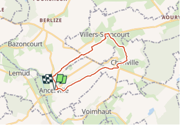
Trail Walking of 10.9 km to be discovered at Grand Est, Moselle, Ancerville. This trail is proposed by bstebe.

Description

Départ Eglise d'Ancerville. Boucle contrastée de taille moyenne alternant parcours en fond de vallée le long de ruisseaux et vastes panoramas depuis les coteaux Grosses côtes et Haut de la Laume

Elevation profile

Positioning

Country:
France
Region :
Grand Est
Department/Province :
Moselle
Municipality :
Ancerville
Location:
Unknown
Start:(UTM)
309121 ; 5434143 (32U) N.

Trails nearby

Trail Walking Rémilly - Remilly et le Haut de Saint-Pierre - Photo
Walking
tracegps

Walking

Medium
Rémilly, Grand Est, Moselle, France
21 km | 25 km-effort
5h 30min
Yes
Trail Walking Villers-Stoncourt - mt st pierre - Photo
Walking
vyp

Walking

Very easy
Villers-Stoncourt, Grand Est, Moselle, France
12.1 km | 14.6 km-effort
3h 5min
No
Trail Other activity Rémilly - Grand Est - Ligne 172 - Rémilly Stiring-Wendel - Photo
Other activity
mich54

Other activity

Very easy
Rémilly, Grand Est, Moselle, France
52 km | 57 km-effort
5min
No
Trail Walking Bazoncourt - Bazoncourt 21 avril 2013 - Photo
Walking
lbu

Walking

Very easy
Bazoncourt, Grand Est, Moselle, France
15.3 km | 17.6 km-effort
3h 1min
Yes
Trail Mountain bike Lemud - 14 07 - Photo
Mountain bike
FAE57

Mountain bike

Medium
Lemud, Grand Est, Moselle, France
40 km | 47 km-effort
2h 38min
Yes
Trail Walking Rémilly - 240420 - Photo
Walking
Bob5757

Walking

Very easy
Rémilly, Grand Est, Moselle, France
5.2 km | 5.9 km-effort
14h 55min
No
Trail Walking Rémilly - marche du don du sang - Photo
Walking
pida

Walking

Very easy
Rémilly, Grand Est, Moselle, France
6.7 km | 8.3 km-effort
1h 45min
Yes
Trail Walking Rémilly - 260420 - Photo
Walking
Bob5757

Walking

Very easy
Rémilly, Grand Est, Moselle, France
1.5 km | 1.6 km-effort
1h 6min
Yes
Trail Walking Rémilly - 200420 - Photo
Walking
Bob5757

Walking

Very easy
Rémilly, Grand Est, Moselle, France
1.2 km | 1.3 km-effort
16min
No


Close
My subscriptions