Trail Mountain bike Digne-les-Bains - La dalle aux Ammonites - Digne-les-Bains  - Photo
 tracegps
tracegps

User

© OpenStreetMap contributors
Length
Length
23 km
Max alt
Max alt
1448 m
Uphill gradient
Uphill gradient
1058 m
Km-Effort
Km-Effort  
37 km
Min alt
Min alt
627 m
Downhill gradient
Downhill gradient
1053 m
Boucle
Boucle
Yes
Creation date :
2014-12-10 00:00:00.0
Updated on :
2014-12-10 00:00:00.0

(0 Reviews)

Mountain bike
Mountain bike
3h30
Difficulty : Very difficult

Scan this QR Code to open this trail in the SityTrail application

FREE GPS app for hiking

Logo SityTrail SityTrail

IGN / Geographical institutes

Download SityTrail from the App Store Download SityTrail from Google Play

Logo SityTrail SityTrail World

The world is yours!

Download SityTrail from the App Store Download SityTrail from Google Play Download SityTrail on Huawei AppGallery

About

Trail Mountain bike of 23 km to be discovered at Provence-Alpes-Côte d'Azur, Alpes-de-Haute-Provence, Digne-les-Bains. This trail is proposed by tracegps.

Description

Une boucle au départ de la Dalle à Ammonites, la montée intermédiaire est très très longue, mais la descente technique est une belle récompense. Quelques portages sur la fin (traversées de ruisseau à sec). Attention la première montée est très compliquée, impossible si humide. Il vaut mieux passer par le chemin "FFC n°6" un peu plus au Nord.

Elevation profile

Photos

Positioning

Country:
France
Region :
Provence-Alpes-Côte d'Azur
Department/Province :
Alpes-de-Haute-Provence
Municipality :
Digne-les-Bains
Location:
Unknown
Start:(UTM)
278672 ; 4888775 (32T) N.

Trails nearby

Trail Walking Digne-les-Bains - Le Cousson - Photo
Walking
Marco05

Walking

Difficult
(1)
Digne-les-Bains, Provence-Alpes-Côte d'Azur, Alpes-de-Haute-Provence, France
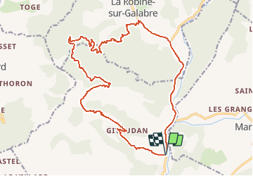
15.4 km | 29 km-effort
6h 39min
Yes
Trail Walking Digne-les-Bains - Autour de Courbons - Digne les Bains - Photo
Walking
tracegps

Walking

Medium
(1)
Digne-les-Bains, Provence-Alpes-Côte d'Azur, Alpes-de-Haute-Provence, France
12.6 km | 18.4 km-effort
5h 0min
Yes
Trail Walking Digne-les-Bains - 65bis-Digne- Cousson N et S- Caramantran- Digne  - Photo
Walking
dumotier

Walking

Medium
(1)
Digne-les-Bains, Provence-Alpes-Côte d'Azur, Alpes-de-Haute-Provence, France
17.4 km | 32 km-effort
3h 49min
Yes
Trail Mountain bike Digne-les-Bains - Terres Noires 2011 (50km) - Photo
Mountain bike
tracegps

Mountain bike

Difficult
(2)
Digne-les-Bains, Provence-Alpes-Côte d'Azur, Alpes-de-Haute-Provence, France
46 km | 63 km-effort
5h 0min
Yes
Trail Walking Digne-les-Bains - Chapelle St Pancrace 18.11.23 - Photo
Walking
fredetpascale

Walking

Easy
Digne-les-Bains, Provence-Alpes-Côte d'Azur, Alpes-de-Haute-Provence, France
5.2 km | 8.3 km-effort
1h 50min
Yes
Trail Walking Digne-les-Bains - Rando Col de Peipin Courbons - Photo
Walking
Marchopier

Walking

Medium
Digne-les-Bains, Provence-Alpes-Côte d'Azur, Alpes-de-Haute-Provence, France
18.5 km | 27 km-effort
5h 55min
Yes
Trail Walking Digne-les-Bains - COURBONS  , Le tour du Rouveyret o - Photo
Walking
RobinMicheline

Walking

Difficult
Digne-les-Bains, Provence-Alpes-Côte d'Azur, Alpes-de-Haute-Provence, France
15.7 km | 23 km-effort
3h 30min
Yes
Trail On foot Marcoux - La Crête de Liman - Photo
On foot
PRO

On foot

Easy
Marcoux, Provence-Alpes-Côte d'Azur, Alpes-de-Haute-Provence, France
10 km | 18.5 km-effort
4h 12min
No
Trail Motorbike Digne-les-Bains - GTA 2018 - ETAPE 8 - Photo
Motorbike
lagardienne

Motorbike

Easy
Digne-les-Bains, Provence-Alpes-Côte d'Azur, Alpes-de-Haute-Provence, France
247 km | 308 km-effort
10h 20min
No


Close
My subscriptions