Trail Mountain bike Agnac - Iffour, randonnée en Guyenne - Agnac - Photo

Iffour, randonnée en Guyenne - Agnac

 tracegps
tracegps

User

© OpenStreetMap contributors
Length
Length
10.2 km
Max alt
Max alt
122 m
Uphill gradient
Uphill gradient
175 m
Km-Effort
Km-Effort  
12.5 km
Min alt
Min alt
67 m
Downhill gradient
Downhill gradient
175 m
Boucle
Boucle
Yes
Creation date :
2014-12-10 00:00:00.0
Updated on :
2014-12-10 00:00:00.0

(0 Reviews)

Mountain bike
Mountain bike
1h19
Difficulty : Easy

Scan this QR Code to open this trail in the SityTrail application

FREE GPS app for hiking

Logo SityTrail SityTrail

IGN / Geographical institutes

Download SityTrail from the App Store Download SityTrail from Google Play

Logo SityTrail SityTrail World

The world is yours!

Download SityTrail from the App Store Download SityTrail from Google Play Download SityTrail on Huawei AppGallery

About

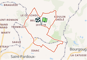
Trail Mountain bike of 10.2 km to be discovered at New Aquitaine, Lot-et-Garonne, Agnac. This trail is proposed by tracegps.

Description

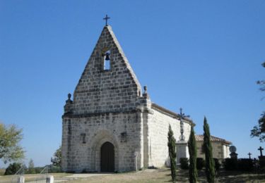
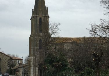
Départ de l'église d'Iffour. Iffour, un des trois hameaux de la commune d’Agnac, est blotti autour de son église et d’un site Bienvenue à la Ferme(*). Ce circuit traverse quelques zones boisées et des coteaux à dominante céréalière. Téléchargez la fiche de cette randonnée sur le site du Tourisme du Lot et Garonne. (*)«Bienvenue à la Ferme» en Lot-et-Garonne. La ferme de Thierry Arnal, située à Iffour, produit des canards gras. Elle est l’un des 92 établissements qui ont choisi l'excellence de la marque Bienvenue à la Ferme. Dans ce réseau, les agriculteurs vous accueillent dans leur ferme où riment générosité, douceur de vivre, saveurs, accueil et découvertes de nos vergers, vignes, maraîchage, élevages et une palette de produits frais et transformés aux saveurs typiques de nos terroirs. Venez dormir à la belle étoile, en camping ou en gîte, ou casser la croûte en savourant nos excellents produits fermiers dans un environnement agréable et calme ! Laissez-vous guider vers une promenade à cheval ou une visite de ferme et nous vous initierons à nos savoir-faire !

Elevation profile

Photos

Positioning

Country:
France
Region :
New Aquitaine
Department/Province :
Lot-et-Garonne
Municipality :
Agnac
Location:
Unknown
Start:(UTM)
292677 ; 4944992 (31T) N.

Trails nearby

Trail Walking Soumensac - Du lac de l'Escourroux vers les coteaux de vignes - Soumensac - Photo
Walking
tracegps

Walking

Medium
Soumensac, New Aquitaine, Lot-et-Garonne, France
6.2 km | 7.6 km-effort
2h 15min
Yes
Trail Mountain bike Saint-Pardoux-Isaac - Vers l'église de Saint-Laurent - Saint-Pardoux-Isaac - Photo
Mountain bike
tracegps

Mountain bike

Easy
Saint-Pardoux-Isaac, New Aquitaine, Lot-et-Garonne, France
11.2 km | 13.3 km-effort
1h 25min
Yes
Trail Walking Saint-Pardoux-Isaac - Vers l'église de Saint-Laurent - Saint-Pardoux-Isaac - Photo
Walking
tracegps

Walking

Medium
(1)
Saint-Pardoux-Isaac, New Aquitaine, Lot-et-Garonne, France
11.2 km | 13.3 km-effort
2h 49min
Yes
Trail Walking Bourgougnague - Bourgougnague 2 - Photo
Walking
Briarwood

Walking

Easy
Bourgougnague, New Aquitaine, Lot-et-Garonne, France
49 km | 55 km-effort
1h 45min
No
Trail Walking Bourgougnague - Bourgougnague - Photo
Walking
Briarwood

Walking

Medium
Bourgougnague, New Aquitaine, Lot-et-Garonne, France
7.5 km | 8.6 km-effort
2h 27min
Yes
Trail Mountain bike Miramont-de-Guyenne - Tour de Miramont de Guyenne - Photo
Mountain bike
tracegps

Mountain bike

Medium
Miramont-de-Guyenne, New Aquitaine, Lot-et-Garonne, France
12.6 km | 15 km-effort
49min
Yes
Trail Mountain bike Saint-Pardoux-Isaac - Balade semi-urbaine à Saint Pardoux Isaac - Photo
Mountain bike
tracegps

Mountain bike

Easy
Saint-Pardoux-Isaac, New Aquitaine, Lot-et-Garonne, France
6.2 km | 7.5 km-effort
45min
Yes
Trail Walking Saint-Pardoux-Isaac - Balade semi-urbaine à Saint Pardoux Isaac - Photo
Walking
tracegps

Walking

Easy
Saint-Pardoux-Isaac, New Aquitaine, Lot-et-Garonne, France
6.2 km | 7.5 km-effort
2h 19min
Yes
Trail Running Agnac - Iffour, randonnée en Guyenne - Agnac - Photo
Running
tracegps

Running

Easy
Agnac, New Aquitaine, Lot-et-Garonne, France
10.2 km | 12.5 km-effort
1h 49min
Yes


Close
My subscriptions