


Cerbère frontières

taguette
User
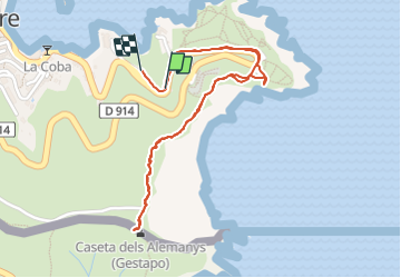

Length
2.7 km

Max alt
146 m

Uphill gradient
140 m
Km-Effort
4.6 km

Min alt
8 m

Downhill gradient
144 m
Boucle
Yes
Creation date :
2022-03-19 07:27:53.598
Updated on :
2022-03-19 08:56:42.438
40m
Difficulty : Easy

FREE GPS app for hiking
 SityTrail
IGN / Geographical institutes
SityTrail Plus
The world is yours!
About
Trail Walking of 2.7 km to be discovered at Occitania, Pyrénées-Orientales, Cerbère. This trail is proposed by taguette.
Positioning
Country:
France
Region :
Occitania
Department/Province :
Pyrénées-Orientales
Municipality :
Cerbère
Location:
Unknown
Start:(Dec)
Start:(UTM)
514144 ; 4698565 (31T) N.
Comments