Trail Walking Eynesse - Randonnée à Eynesse - Photo

Randonnée à Eynesse

 tracegps
tracegps

User

© OpenStreetMap contributors
Length
Length
3.9 km
Max alt
Max alt
97 m
Uphill gradient
Uphill gradient
93 m
Km-Effort
Km-Effort  
5.1 km
Min alt
Min alt
9 m
Downhill gradient
Downhill gradient
94 m
Boucle
Boucle
Yes
Creation date :
2014-12-10 00:00:00.0
Updated on :
2014-12-10 00:00:00.0

(0 Reviews)

Walking
Walking
1h00
Difficulty : Easy

Scan this QR Code to open this trail in the SityTrail application

FREE GPS app for hiking

Logo SityTrail SityTrail

IGN / Geographical institutes

Download SityTrail from the App Store Download SityTrail from Google Play

Logo SityTrail SityTrail World

The world is yours!

Download SityTrail from the App Store Download SityTrail from Google Play Download SityTrail on Huawei AppGallery

About

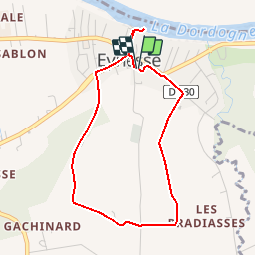
Trail Walking of 3.9 km to be discovered at New Aquitaine, Gironde, Eynesse. This trail is proposed by tracegps.

Description

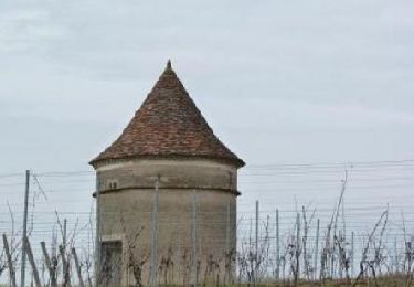
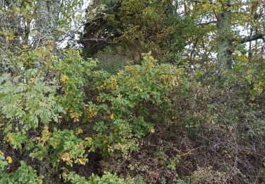
Petit circuit de 3.9 km partant du village d’Eynesse en Gironde au bord de la rivière Dordogne. Le promeneur monte dans les collines au Sud pour admirer le panorama près des 2 moulins dont l’un est bien restauré (96m de dénivelé). Le départ se fait du parking de l’école puis suivre la balise vers le terrain de sport

Elevation profile

Photos

Positioning

Country:
France
Region :
New Aquitaine
Department/Province :
Gironde
Municipality :
Eynesse
Location:
Unknown
Start:(UTM)
275117 ; 4967349 (31T) N.

Trails nearby

Trail Walking Les Lèves-et-Thoumeyragues - Les Lèves par La Tour - Photo
Walking
tracegps

Walking

Medium
Les Lèves-et-Thoumeyragues, New Aquitaine, Gironde, France
11.2 km | 13.6 km-effort
2h 49min
Yes
Trail Walking Les Lèves-et-Thoumeyragues - Le circuit des moulins  -   Les Lèves-et-Thoumeyragues  - Photo
Walking
tracegps

Walking

Medium
(1)
Les Lèves-et-Thoumeyragues, New Aquitaine, Gironde, France
10.3 km | 12.8 km-effort
2h 34min
Yes
Trail Walking Les Lèves-et-Thoumeyragues - les leves - Photo
Walking
leglisemichel

Walking

Very easy
Les Lèves-et-Thoumeyragues, New Aquitaine, Gironde, France
11.1 km | 13.7 km-effort
3h 5min
Yes
Trail Walking Les Lèves-et-Thoumeyragues - les les thoumeyragues - la beauze - Photo
Walking
danielletara

Walking

Medium
(1)
Les Lèves-et-Thoumeyragues, New Aquitaine, Gironde, France
7.7 km | 9.3 km-effort
1h 55min
Yes
Trail Walking Saint-Quentin-de-Caplong - De St Quentin de Caplong à Monsegur puis Coutures - Photo
Walking
000843.e2af63ba812d4dc4a845c93df243350a.2104

Walking

Very difficult
Saint-Quentin-de-Caplong, New Aquitaine, Gironde, France
33 km | 39 km-effort
6h 43min
No
Trail Walking Pineuilh - Port Ste Foy la Grande     Saint Ferme - Photo
Walking
Lionel_72

Walking

Easy
Pineuilh, New Aquitaine, Gironde, France
23 km | 29 km-effort
4h 53min
No
Trail Walking Port-Sainte-Foy-et-Ponchapt - P05 Port Ste Foy-Pellegrue - Photo
Walking

Walking

Very difficult
Port-Sainte-Foy-et-Ponchapt, New Aquitaine, Dordogne, France
23 km | 27 km-effort
6h 0min
No
Trail Walking Saint-Antoine-de-Breuilh - Boucle des Laurents - Photo
Walking
amelie14

Walking

Very easy
Saint-Antoine-de-Breuilh, New Aquitaine, Dordogne, France
11.3 km | 12 km-effort
2h 24min
Yes
Trail Walking Fougueyrolles - Fougueyrolles à Vélines - Photo
Walking
gersimcar

Walking

Medium
Fougueyrolles, New Aquitaine, Dordogne, France
16.5 km | 18.8 km-effort
5h 0min
Yes


Close
My subscriptions