


Guebwiller rue de l’ermite

philvor
User
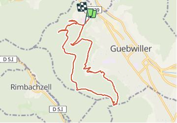

Length
9.9 km

Max alt
517 m

Uphill gradient
318 m
Km-Effort
14.2 km

Min alt
331 m

Downhill gradient
338 m
Boucle
No
Creation date :
2022-03-19 09:19:41.0
Updated on :
2022-03-19 16:01:44.532
4h00
Difficulty : Easy

FREE GPS app for hiking
 SityTrail
IGN / Geographical institutes
SityTrail Plus
The world is yours!
About
Trail Walking of 9.9 km to be discovered at Grand Est, Haut-Rhin, Guebwiller. This trail is proposed by philvor.
Positioning
Country:
France
Region :
Grand Est
Department/Province :
Haut-Rhin
Municipality :
Guebwiller
Location:
Unknown
Start:(Dec)
Start:(UTM)
365150 ; 5308440 (32T) N.
Comments