Trail Walking Logrian-Florian - Logrian, le Castellas  - Photo

Logrian, le Castellas

 tracegps
tracegps

User

© OpenStreetMap contributors
Length
Length
12.8 km
Max alt
Max alt
227 m
Uphill gradient
Uphill gradient
268 m
Km-Effort
Km-Effort  
16.4 km
Min alt
Min alt
77 m
Downhill gradient
Downhill gradient
269 m
Boucle
Boucle
Yes
Creation date :
2014-12-10 00:00:00.0
Updated on :
2014-12-10 00:00:00.0

(1 Reviews)

Walking
Walking
3h30
Difficulty : Medium

Scan this QR Code to open this trail in the SityTrail application

FREE GPS app for hiking

Logo SityTrail SityTrail

IGN / Geographical institutes

Download SityTrail from the App Store Download SityTrail from Google Play

Logo SityTrail SityTrail World

The world is yours!

Download SityTrail from the App Store Download SityTrail from Google Play Download SityTrail on Huawei AppGallery

About

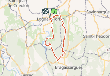
Trail Walking of 12.8 km to be discovered at Occitania, Gard, Logrian-Florian. This trail is proposed by tracegps.

Description

Balade facile sur le plateau de Puechredon, visite d'un castellas et du lac de la Rouvière. Du parking au bas du village de Logrian, remonter en direction du village et enfiler la rue du porche à gauche, poursuivre sur le bon chemin et arriver à la D8 que l'on suit à gauche sur 300m. Prendre à droite un chemin vers le sud qui rejoint un talweg. Rejoindre les ruines d'un "castel" et chercher la porte du château pour trouver la sente qui descend aux bas des falaises d'escalade et rejoint la route D118. Rester sur un chemin entre forêt et vignes. Passer Nogarède et monter à droite. Suivre la trace GPS et rejoindre le lac de la Rouvière. Possibilité de faire un aller retour pour visiter le hameau de Florian (pont sur le Crieulon). Regagner le village de Logrian. Attention ! La trace GPS ne suit pas toujours le balisage.

Elevation profile

Photos

Positioning

Country:
France
Region :
Occitania
Department/Province :
Gard
Municipality :
Logrian-Florian
Location:
Unknown
Start:(UTM)
582535 ; 4867609 (31T) N.

Comments

Please log in to post a review or rate the element


Trails nearby

Trail Walking Durfort-et-Saint-Martin-de-Sossenac - circuit Durfort 2 - Photo
Walking
jeanjacques13

Walking

Easy
(1)
Durfort-et-Saint-Martin-de-Sossenac, Occitania, Gard, France
8.1 km | 9.9 km-effort
2h 8min
Yes
Trail Trail Sauve - Sauve - Photo
Trail
Daniel Habert

Trail

Very easy
(1)
Sauve, Occitania, Gard, France
4.2 km | 4.6 km-effort
35min
Yes
Trail Walking Quissac - Quissac Bragassargues le 10 février 2022 - Photo
Walking
jesusmarieclaire

Walking

Very easy
(1)
Quissac, Occitania, Gard, France
10.2 km | 12.3 km-effort
2h 48min
Yes
Trail Walking Savignargues - Savigargues - Photo
Walking
marcheur75

Walking

Medium
Savignargues, Occitania, Gard, France
6.2 km | 6.9 km-effort
1h 18min
Yes
Trail Walking Quissac - Quissac (château de la Rouvière, chapelle de Pizé) - Photo
Walking
coulombf

Walking

Difficult
Quissac, Occitania, Gard, France
13.6 km | 16.6 km-effort
3h 46min
Yes
Trail Walking Quissac - Quissac-Chapelle de Pisé - Photo
Walking
gscholasch

Walking

Easy
Quissac, Occitania, Gard, France
14.1 km | 17.2 km-effort
5h 17min
Yes
Trail Mountain bike Quissac - Quissac Anduze - Photo
Mountain bike
GUIDE
Roger Philippe Wallez

Mountain bike

Medium
Quissac, Occitania, Gard, France
18.9 km | 21 km-effort
1h 28min
No
Trail Walking Logrian-Florian - L’augurant - Photo
Walking
GUIDE
Roger Philippe Wallez

Walking

Medium
Logrian-Florian, Occitania, Gard, France
10.7 km | 12 km-effort
3h 30min
Yes
Trail Mountain bike Sauve - Sauve Corcone Quisac - Photo
Mountain bike
inesmyt

Mountain bike

Very difficult
Sauve, Occitania, Gard, France
28 km | 34 km-effort
5h 20min
Yes


Close
My subscriptions