


kientzheim riquewihr

jcschubnel
User
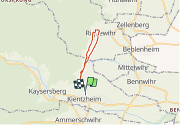

Length
7.9 km

Max alt
345 m

Uphill gradient
179 m
Km-Effort
10.3 km

Min alt
222 m

Downhill gradient
182 m
Boucle
Yes
Creation date :
2022-03-21 13:38:12.449
Updated on :
2022-03-22 01:44:09.516
2h30
Difficulty : Medium

FREE GPS app for hiking
 SityTrail
IGN / Geographical institutes
SityTrail Plus
The world is yours!
About
Trail Walking of 7.9 km to be discovered at Grand Est, Haut-Rhin, Kaysersberg-Vignoble. This trail is proposed by jcschubnel.
Positioning
Country:
France
Region :
Grand Est
Department/Province :
Haut-Rhin
Municipality :
Kaysersberg-Vignoble
Location:
Kientzheim
Start:(Dec)
Start:(UTM)
372600 ; 5333090 (32U) N.
Comments