Trail Mountain bike Bujaleuf - Au nord de Bujaleuf  - Photo
 tracegps
tracegps

User

© OpenStreetMap contributors
Length
Length
40 km
Max alt
Max alt
556 m
Uphill gradient
Uphill gradient
1014 m
Km-Effort
Km-Effort  
53 km
Min alt
Min alt
327 m
Downhill gradient
Downhill gradient
1015 m
Boucle
Boucle
Yes
Creation date :
2014-12-10 00:00:00.0
Updated on :
2014-12-10 00:00:00.0

(0 Reviews)

Mountain bike
Mountain bike
3h30
Difficulty : Medium

Scan this QR Code to open this trail in the SityTrail application

FREE GPS app for hiking

Logo SityTrail SityTrail

IGN / Geographical institutes

Download SityTrail from the App Store Download SityTrail from Google Play

Logo SityTrail SityTrail World

The world is yours!

Download SityTrail from the App Store Download SityTrail from Google Play Download SityTrail on Huawei AppGallery

About

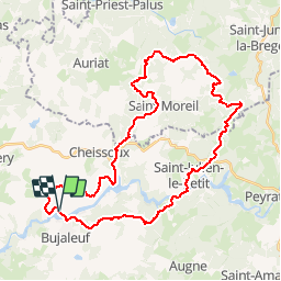
Trail Mountain bike of 40 km to be discovered at New Aquitaine, Haute-Vienne, Bujaleuf. This trail is proposed by tracegps.

Description

Petite balade autour de Bujaleuf. Départ du parking au bord du lac, prés du lotissement du lac.

Elevation profile

Photos

Positioning

Country:
France
Region :
New Aquitaine
Department/Province :
Haute-Vienne
Municipality :
Bujaleuf
Location:
Unknown
Start:(UTM)
393116 ; 5073559 (31T) N.

Trails nearby

Trail Walking Augne - Le ranch des lacs eymoutiers - Photo
Walking
Jamartrita

Walking

Easy
Augne, New Aquitaine, Haute-Vienne, France
8.5 km | 10.3 km-effort
2h 32min
No
Trail Walking Champnétery - champneterie - Photo
Walking
vignaud

Walking

Very easy
Champnétery, New Aquitaine, Haute-Vienne, France
11.8 km | 14.6 km-effort
2h 52min
Yes


Close
My subscriptions