Trail Walking Affieux - Le rocher des folles - Affieux - Photo

Le rocher des folles - Affieux

 tracegps
tracegps

User

© OpenStreetMap contributors
Length
Length
9.7 km
Max alt
Max alt
588 m
Uphill gradient
Uphill gradient
203 m
Km-Effort
Km-Effort  
12.4 km
Min alt
Min alt
481 m
Downhill gradient
Downhill gradient
202 m
Boucle
Boucle
Yes
Creation date :
2014-12-10 00:00:00.0
Updated on :
2014-12-10 00:00:00.0

(1 Reviews)

Walking
Walking
2h30
Difficulty : Medium

Scan this QR Code to open this trail in the SityTrail application

FREE GPS app for hiking

Logo SityTrail SityTrail

IGN / Geographical institutes

Download SityTrail from the App Store Download SityTrail from Google Play

Logo SityTrail SityTrail World

The world is yours!

Download SityTrail from the App Store Download SityTrail from Google Play Download SityTrail on Huawei AppGallery

About

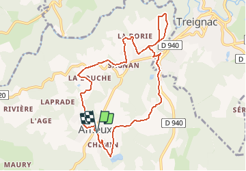
Trail Walking of 9.7 km to be discovered at New Aquitaine, Corrèze, Affieux. This trail is proposed by tracegps.

Description

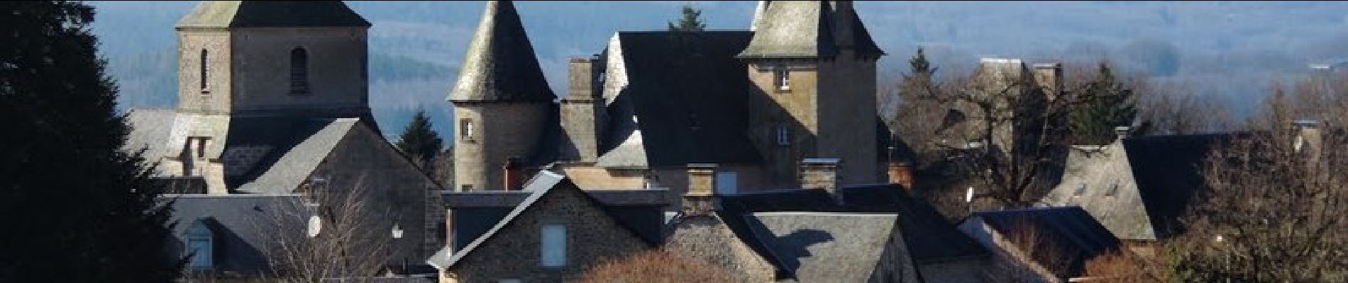
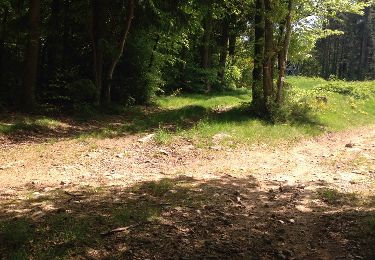
Alternant les paysages de plaine et de sous-bois, cette boucle chemine sur les hauteurs, offrant de superbes points de vue sur la campagne. En traversant de petits hameaux pleins de charmes, elle conduit à l'étang de Linatre, au bord duquel patientent toujours quelques pêcheurs. Le vieux bourg d'Affieux fait partie d'un site inscrit incluant le château (privé) du XVIIe siècle et l'église de Saint-Pardoux. La gare, aujourd'hui restaurée, accueillait l'ancien POC (Paris-Orléans-Corrèze). Attention : l'accès au site du Rocher des Folles est interdit aux vététistes et cavaliers (dangereux). (Le nom provient du fait que des femmes se jetaient dans la Vézère du haut de se rocher, les seigneurs de Treignac pratiquant la coutume de l'époque de "droit de cuissage".) Crédit photos lacorreze.com. Téléchargez la fiche du circuit sur le site du Tourisme en Limousin.

Elevation profile

Photos

Positioning

Country:
France
Region :
New Aquitaine
Department/Province :
Corrèze
Municipality :
Affieux
Location:
Unknown
Start:(UTM)
403817 ; 5041124 (31T) N.

Comments

Please log in to post a review or rate the element


Trails nearby

Trail Walking Treignac - circuit 2 depuis le centre - Photo
Walking
nico_be

Walking

Difficult
(1)
Treignac, New Aquitaine, Corrèze, France
10.9 km | 14.8 km-effort
3h 22min
Yes
Trail Walking Treignac - Treignac Trephy - Photo
Walking
Jamartrita

Walking

Easy
Treignac, New Aquitaine, Corrèze, France
18.1 km | 24 km-effort
6h 25min
No
Trail Walking Treignac - Treignac Trephy - Photo
Walking
Jamartrita

Walking

Easy
Treignac, New Aquitaine, Corrèze, France
18.1 km | 24 km-effort
6h 25min
No
Trail Motor Treignac - tregnac - Photo
Motor
fnunes

Motor

Easy
Treignac, New Aquitaine, Corrèze, France
41 km | 55 km-effort
1h 49min
Yes
Trail Mountain bike Treignac - Treignac 2022 - Photo
Mountain bike
pates_au_chaud

Mountain bike

Difficult
Treignac, New Aquitaine, Corrèze, France
30 km | 40 km-effort
3h 8min
Yes
Trail On foot Treignac - GR440 jour 4: Hotel du Lac à Lieu de bivouac - Photo
On foot
MathieuBourgois

On foot

Easy
Treignac, New Aquitaine, Corrèze, France
26 km | 36 km-effort
2h 9min
No
Trail Walking Treignac - treignac 1 - Photo
Walking
personono

Walking

Medium
Treignac, New Aquitaine, Corrèze, France
4 km | 5.2 km-effort
1h 49min
No
Trail Walking Madranges - Madranges-Circuit des 2 clochers - Photo
Walking
houbart

Walking

Very easy
Madranges, New Aquitaine, Corrèze, France
11.3 km | 15 km-effort
3h 14min
Yes
Trail Running Treignac - MMRT  suiveurs voitures - Photo
Running
F0DDS

Running

Easy
Treignac, New Aquitaine, Corrèze, France
46 km | 61 km-effort
1h 33min
No


Close
My subscriptions