


fournache peclet polset

Bernadette Noirant
User
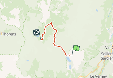

Length
14.9 km

Max alt
2914 m

Uphill gradient
1168 m
Km-Effort
30 km

Min alt
1968 m

Downhill gradient
1041 m
Boucle
No
Creation date :
2022-03-25 20:00:29.595
Updated on :
2022-03-25 20:00:34.601
6h49
Difficulty : Very difficult

FREE GPS app for hiking
 SityTrail
IGN / Geographical institutes
SityTrail Plus
The world is yours!
About
Trail Walking of 14.9 km to be discovered at Auvergne-Rhône-Alpes, Savoy, Aussois. This trail is proposed by Bernadette Noirant.
Positioning
Country:
France
Region :
Auvergne-Rhône-Alpes
Department/Province :
Savoy
Municipality :
Aussois
Location:
Unknown
Start:(Dec)
Start:(UTM)
321668 ; 5014934 (32T) N.
Comments