Trail Walking Sos - De Sos à Poudenas sur le chemin de Gélise - Photo

De Sos à Poudenas sur le chemin de Gélise

 tracegps
tracegps

User

© OpenStreetMap contributors
Length
Length
17 km
Max alt
Max alt
168 m
Uphill gradient
Uphill gradient
239 m
Km-Effort
Km-Effort  
20 km
Min alt
Min alt
65 m
Downhill gradient
Downhill gradient
239 m
Boucle
Boucle
Yes
Creation date :
2014-12-10 00:00:00.0
Updated on :
2014-12-10 00:00:00.0

(0 Reviews)

Walking
Walking
4h19
Difficulty : Difficult

Scan this QR Code to open this trail in the SityTrail application

FREE GPS app for hiking

Logo SityTrail SityTrail

IGN / Geographical institutes

Download SityTrail from the App Store Download SityTrail from Google Play

Logo SityTrail SityTrail World

The world is yours!

Download SityTrail from the App Store Download SityTrail from Google Play Download SityTrail on Huawei AppGallery

About

Trail Walking of 17 km to be discovered at New Aquitaine, Lot-et-Garonne, Sos. This trail is proposed by tracegps.

Description

Cette verte vallée étroite et encaissée recèle des trésors de surprises: des cités à la personnalité affirmée, une végétation riche et luxuriante. Pour les découvrir, suivez l’ancienne voie ferrée de Sos à Mézin. Départ de la place Emmanuel Delbousquet de Sos. Téléchargez la fiche de cette randonnée sur le site du Tourisme du Lot et Garonne.

Elevation profile

Photos

Positioning

Country:
France
Region :
New Aquitaine
Department/Province :
Lot-et-Garonne
Municipality :
Sos
Location:
Unknown
Start:(UTM)
270991 ; 4880548 (31T) N.

Trails nearby

Trail On foot Sos - De Sos à Poudenas sur le chemin de Gélise 17.2 km - Photo
On foot
PRO

On foot

Medium
Sos, New Aquitaine, Lot-et-Garonne, France
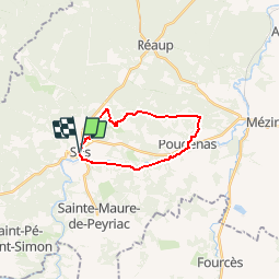
17.1 km | 20 km-effort
4h 36min
Yes
Trail Snowshoes Sos - raquettes et rando Azet 2 circuits - Photo
Snowshoes
Forsans

Snowshoes

Very easy
Sos, New Aquitaine, Lot-et-Garonne, France
170 km | 258 km-effort
3h 30min
No
Trail Equestrian Sos - De Sos à Poudenas sur le chemin de Gélise - Photo
Equestrian
tracegps

Equestrian

Medium
Sos, New Aquitaine, Lot-et-Garonne, France
17 km | 20 km-effort
2h 49min
Yes
Trail Mountain bike Sos - De Sos à Poudenas sur le chemin de Gélise - Photo
Mountain bike
tracegps

Mountain bike

Medium
Sos, New Aquitaine, Lot-et-Garonne, France
17 km | 20 km-effort
2h 10min
Yes
Trail On foot Sainte-Maure-de-Peyriac - Sainte-Maure-de-Peyriac, l'arbre et le cep 14 km - Photo
On foot
PRO

On foot

Easy
Sainte-Maure-de-Peyriac, New Aquitaine, Lot-et-Garonne, France
13.9 km | 16.3 km-effort
3h 42min
Yes
Trail On foot Saint-Pé-Saint-Simon - Saint-Pé-Saint-Simon, aux confins du Gers et des Landes 9.4 km - Photo
On foot
PRO

On foot

Easy
Saint-Pé-Saint-Simon, New Aquitaine, Lot-et-Garonne, France
9.4 km | 11 km-effort
2h 29min
Yes
Trail On foot Sos - Sos, Meylan, balade entre pins et chênes 5.9 km - Photo
On foot
PRO

On foot

Easy
Sos, New Aquitaine, Lot-et-Garonne, France
6.3 km | 7.8 km-effort
1h 46min
Yes
Trail On foot Sos - Sos, De Gueyze à Meylan, au fil de la Gueyze 11.3 km - Photo
On foot
PRO

On foot

Easy
Sos, New Aquitaine, Lot-et-Garonne, France
11.4 km | 13.9 km-effort
3h 9min
Yes
Trail On foot Sos - Sos, la promenade de Campet 7.9 km - Photo
On foot
PRO

On foot

Easy
Sos, New Aquitaine, Lot-et-Garonne, France
8 km | 9.8 km-effort
2h 13min
Yes


Close
My subscriptions