Trail Walking Fumel - Le GR de pays du château de Fumel au château de Bonaguil - Photo

Le GR de pays du château de Fumel au château de Bonaguil

 tracegps
tracegps

User

© OpenStreetMap contributors
Length
Length
9.4 km
Max alt
Max alt
186 m
Uphill gradient
Uphill gradient
211 m
Km-Effort
Km-Effort  
12.1 km
Min alt
Min alt
67 m
Downhill gradient
Downhill gradient
171 m
Boucle
Boucle
No
Creation date :
2014-12-10 00:00:00.0
Updated on :
2014-12-10 00:00:00.0

(0 Reviews)

Walking
Walking
2h30
Difficulty : Medium

Scan this QR Code to open this trail in the SityTrail application

FREE GPS app for hiking

Logo SityTrail SityTrail

IGN / Geographical institutes

Download SityTrail from the App Store Download SityTrail from Google Play

Logo SityTrail SityTrail World

The world is yours!

Download SityTrail from the App Store Download SityTrail from Google Play Download SityTrail on Huawei AppGallery

About

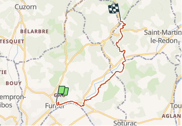
Trail Walking of 9.4 km to be discovered at New Aquitaine, Lot-et-Garonne, Fumel. This trail is proposed by tracegps.

Description

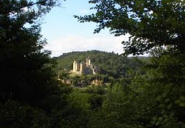
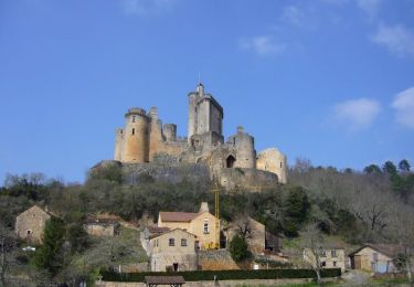
Départ de la place Georges Escande (Office de Tourisme). Ce linéaire, balisé en jaune-rouge, est une étape du GR® de Pays «Châteaux et Bastides en Haut-Agenais Périgord». Il relie le château de Fumel et la rivière Lot au château de Bonaguil, l’un des hauts lieux du Tourisme Lot et Garonnais. Téléchargez la fiche de cette randonnée sur le site du Tourisme du Lot et Garonne.

Elevation profile

Photos

Positioning

Country:
France
Region :
New Aquitaine
Department/Province :
Lot-et-Garonne
Municipality :
Fumel
Location:
Unknown
Start:(UTM)
338599 ; 4929221 (31T) N.

Trails nearby

Trail Walking Saint-Front-sur-Lémance - La randonnée de Bonaguil -Balisage jaune  - Photo
Walking
alainjoseph6

Walking

Medium
Saint-Front-sur-Lémance, New Aquitaine, Lot-et-Garonne, France
8.1 km | 10.4 km-effort
2h 49min
Yes
Trail Walking Saint-Front-sur-Lémance - boucle bonaguil via lastreilles - Photo
Walking
fab0202

Walking

Easy
Saint-Front-sur-Lémance, New Aquitaine, Lot-et-Garonne, France
16.1 km | 21 km-effort
4h 9min
Yes
Trail Equestrian Fumel - Le GR de pays du château de Fumel au château de Bonaguil - Photo
Equestrian
tracegps

Equestrian

Easy
Fumel, New Aquitaine, Lot-et-Garonne, France
9.4 km | 12.1 km-effort
1h 40min
No
Trail Mountain bike Fumel - Le GR de pays du château de Fumel au château de Bonaguil - Photo
Mountain bike
tracegps

Mountain bike

Easy
(1)
Fumel, New Aquitaine, Lot-et-Garonne, France
9.4 km | 12.1 km-effort
1h 15min
No
Trail Mountain bike Saint-Front-sur-Lémance - Bonaguil, sur le GR® 36, entre Périgord et Quercy - Photo
Mountain bike
tracegps

Mountain bike

Medium
Saint-Front-sur-Lémance, New Aquitaine, Lot-et-Garonne, France
9.3 km | 12.3 km-effort
1h 10min
Yes
Trail Walking Saint-Front-sur-Lémance - Bonaguil, sur le GR® 36, entre Périgord et Quercy - Photo
Walking
tracegps

Walking

Medium
Saint-Front-sur-Lémance, New Aquitaine, Lot-et-Garonne, France
9.3 km | 12.3 km-effort
3h 0min
Yes
Trail Motor Fumel - Fumel circuit voiture - Photo
Motor
jmc47500

Motor

Easy
(1)
Fumel, New Aquitaine, Lot-et-Garonne, France
84 km | 104 km-effort
7h 0min
Yes
Trail Walking Cuzorn - tuc blanc - Photo
Walking
adgjm

Walking

Very easy
(1)
Cuzorn, New Aquitaine, Lot-et-Garonne, France
7.6 km | 9.3 km-effort
2h 44min
No
Trail Mountain bike Saint-Vite - saint vite - Photo
Mountain bike
franck47500

Mountain bike

Medium
Saint-Vite, New Aquitaine, Lot-et-Garonne, France
26 km | 30 km-effort
2h 6min
Yes


Close
My subscriptions