Trail Walking Condat-sur-Ganaveix - Du Ganaveix au Bradascou - Condat sur Ganaveix - Photo

Du Ganaveix au Bradascou - Condat sur Ganaveix

 tracegps
tracegps

User

© OpenStreetMap contributors
Length
Length
14.3 km
Max alt
Max alt
445 m
Uphill gradient
Uphill gradient
311 m
Km-Effort
Km-Effort  
18.5 km
Min alt
Min alt
351 m
Downhill gradient
Downhill gradient
311 m
Boucle
Boucle
Yes
Creation date :
2014-12-10 00:00:00.0
Updated on :
2014-12-10 00:00:00.0

(1 Reviews)

Walking
Walking
4h00
Difficulty : Medium

Scan this QR Code to open this trail in the SityTrail application

FREE GPS app for hiking

Logo SityTrail SityTrail

IGN / Geographical institutes

Download SityTrail from the App Store Download SityTrail from Google Play

Logo SityTrail SityTrail World

The world is yours!

Download SityTrail from the App Store Download SityTrail from Google Play Download SityTrail on Huawei AppGallery

About

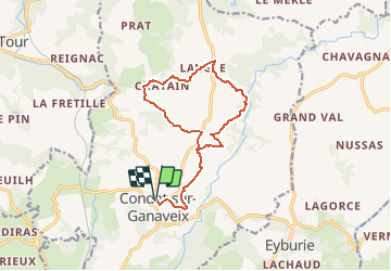
Trail Walking of 14.3 km to be discovered at New Aquitaine, Corrèze, Condat-sur-Ganaveix. This trail is proposed by tracegps.

Description

Invitation à une promenade bucolique au confluent du Ganaveix et du Bradascou. Avec le massif des Monédières et le Mont Gargan pour toile de fond, partez dans le calme et la beauté d'une merveilleuse campagne vallonnée. Mettez vos sens en éveil ! Admirez les vaches limousines, fleuron de notre région, paître et ruminer dans les prés verdoyants ! Ecoutez le gazouillis des oiseaux, le clapotis de l'eau au gré des frayères à truites ! Remarquez au hasard des hameaux paisibles ces maisons de caractère ! Ainsi de village en village, au travers des bois, au-delà des rivières, vous aurez profité de notre campagne. Et, si le cœur vous en dit, revenez visiter la pisciculture du «Moulin de Cluzac» et la cidrerie de «La Tuilerie», activités artisanales typiques de Condat sur Ganaveix ! Téléchargez la fiche du circuit sur le site du Tourisme en Limousin.

Elevation profile

Photos

Positioning

Country:
France
Region :
New Aquitaine
Department/Province :
Corrèze
Municipality :
Condat-sur-Ganaveix
Location:
Unknown
Start:(UTM)
390037 ; 5035994 (31T) N.

Comments

Please log in to post a review or rate the element


Trails nearby

Trail Walking Salon-la-Tour - Entre étangs et châteaux - Salon la Tour - Pays Vézère Auvézère - Photo
Walking
tracegps

Walking

Medium
(2)
Salon-la-Tour, New Aquitaine, Corrèze, France
9.5 km | 12.1 km-effort
3h 30min
Yes
Trail Walking Uzerche - Sur les pas de Simone de Beauvoir - Uzerche - Photo
Walking
tracegps

Walking

Medium
(2)
Uzerche, New Aquitaine, Corrèze, France
5.6 km | 7 km-effort
1h 15min
Yes
Trail Mountain bike Salon-la-Tour - Entre étangs et châteaux - Salon la Tour - Pays Vézère Auvézère - Photo
Mountain bike
tracegps

Mountain bike

Medium
Salon-la-Tour, New Aquitaine, Corrèze, France
9.5 km | 12.1 km-effort
1h 0min
Yes
Trail Mountain bike Uzerche - rando quad uzerche  - Photo
Mountain bike
Joël Chalaud

Mountain bike

Medium
Uzerche, New Aquitaine, Corrèze, France
82 km | 104 km-effort
4h 54min
Yes
Trail Walking Condat-sur-Ganaveix - La Bessade- La Forêt - Photo
Walking
houbart

Walking

Medium
Condat-sur-Ganaveix, New Aquitaine, Corrèze, France
8.4 km | 10.9 km-effort
2h 21min
Yes
Trail Other activity Salon-la-Tour - vigeois-rmb - Photo
Other activity
fengels

Other activity

Very easy
(1)
Salon-la-Tour, New Aquitaine, Corrèze, France
445 km | 501 km-effort
9h 46min
No
Trail Walking Uzerche - Randonnée Uzerche Espartignac Balisage bleu dit le puychamard - Photo
Walking
Titou87123

Walking

Very easy
Uzerche, New Aquitaine, Corrèze, France
10.7 km | 14.4 km-effort
3h 21min
Yes
Trail Motorbike Uzerche - Gorges de la Vézère 1 - Photo
Motorbike
bernard_ostermann

Motorbike

Easy
Uzerche, New Aquitaine, Corrèze, France
152 km | 192 km-effort
4h 0min
No
Trail Walking Uzerche - GR46-07 - Uzerche - Estivaux - Photo
Walking
Tournan

Walking

Medium
Uzerche, New Aquitaine, Corrèze, France
24 km | 34 km-effort
7h 5min
No


Close
My subscriptions