


st-gilles

jcschubnel
User
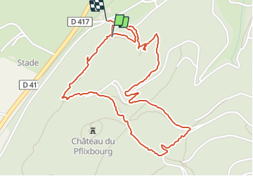

Length
2.9 km

Max alt
427 m

Uphill gradient
142 m
Km-Effort
4.8 km

Min alt
266 m

Downhill gradient
164 m
Boucle
Yes
Creation date :
2022-03-27 12:53:43.452
Updated on :
2022-03-27 16:57:26.648
1h40
Difficulty : Easy

FREE GPS app for hiking
 SityTrail
IGN / Geographical institutes
SityTrail Plus
The world is yours!
About
Trail Walking of 2.9 km to be discovered at Grand Est, Haut-Rhin, Wintzenheim. This trail is proposed by jcschubnel.
Positioning
Country:
France
Region :
Grand Est
Department/Province :
Haut-Rhin
Municipality :
Wintzenheim
Location:
Unknown
Start:(Dec)
Start:(UTM)
370051 ; 5325660 (32U) N.
Comments