![](/images/other/stat-length.png)
Marche Adeps 10 km
rsih
User
![Length](/images/other/stat-length.png)
Length
9.1 km
![Max alt](https://static1.geolcdn.com/siteimages/upload/files/1508320355ic_sort_altitude_max_24dp.png)
Max alt
435 m
![Uphill gradient](https://static1.geolcdn.com/siteimages/upload/files/1508320355ic_sort_den_pos_24dp.png)
Uphill gradient
264 m
![Km-Effort](/images/other/stat-length.png)
Km-Effort
12.6 km
![Min alt](https://static1.geolcdn.com/siteimages/upload/files/1508320355ic_sort_altitude_min_24dp.png)
Min alt
269 m
![Downhill gradient](https://static1.geolcdn.com/siteimages/upload/files/1508320355ic_sort_den_neg_24dp.png)
Downhill gradient
264 m
![Boucle](https://static1.geolcdn.com/siteimages/upload/files/16400158638029165_repeat_loop_refresh_sync_direction_icon.png)
Boucle
Yes
Creation date :
2022-03-28 13:28:12.994
Updated on :
2024-04-18 14:12:06.445
![Walking](https://static1.geolcdn.com/sitytour/trail-icons/101.png)
2h51
Difficulty : Difficult
![Scan this QR Code to open this trail in the SityTrail application](https://capi.geolives.com/qq0zvz2zws4bq2lad0pu/sitytour/trails/3183879/qr.png?size=200)
FREE GPS app for hiking
About
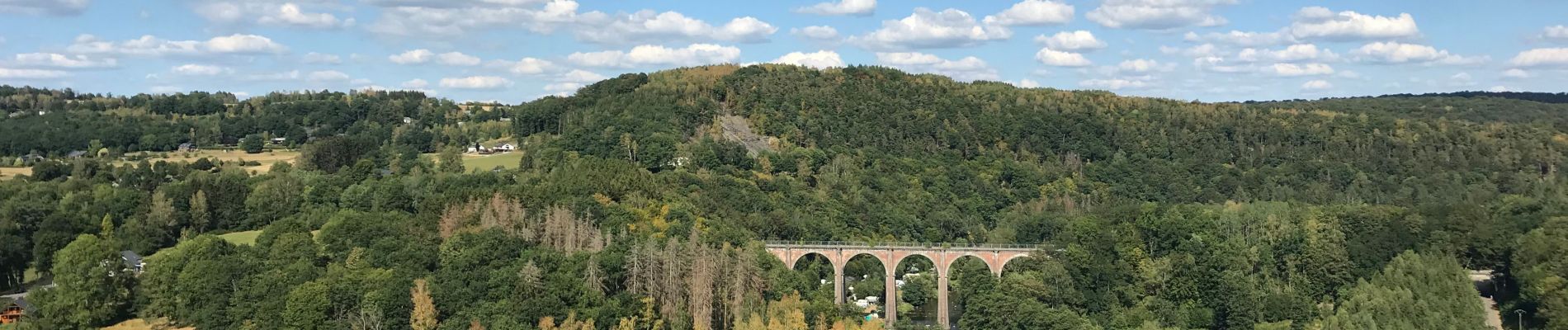
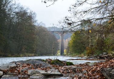
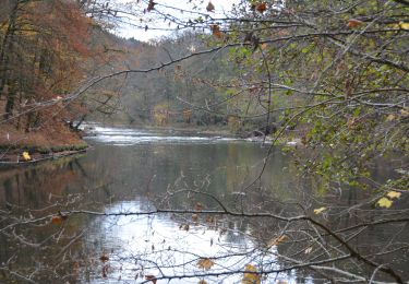
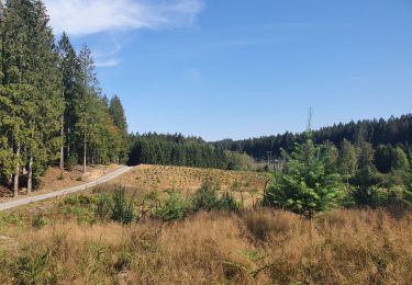
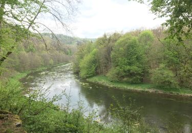
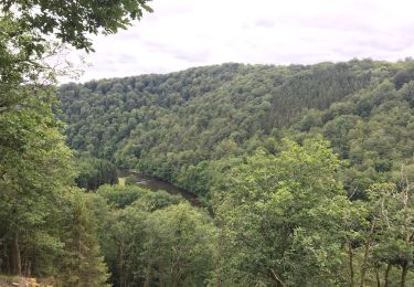
Trail Walking of 9.1 km to be discovered at Wallonia, Luxembourg, Herbeumont. This trail is proposed by rsih.
Description
Magnifique balade passant par l'ancienne voie de chemin de fer 163a, aujourd'hui reconvertie en RAVeL et donnant accès au point de vue de la Roche du Moulin et de Libaipire.
Positioning
Country:
Belgium
Region :
Wallonia
Department/Province :
Luxembourg
Municipality :
Herbeumont
Location:
Unknown
Start:(Dec)
Start:(UTM)
661090 ; 5516689 (31U) N.
Comments
Trails nearby
![Trail Other activity Bertrix - BX08 - Photo](https://media.geolcdn.com/t/375/260/ext.jpg?maxdim=2&url=https%3A%2F%2Fstatic1.geolcdn.com%2Fsiteimages%2Fupload%2Ffiles%2F1545311037marcheuse_200dpi.jpg)
![Other activity Other activity](https://static1.geolcdn.com/sitytour/trail-icons/900.png)
BX08
Other activity
Very easy
(8)
Bertrix,
Wallonia,
Luxembourg,
Belgium
![](/images/other/stat-length.png)
7.3 km | 10 km-effort
2h 30min
![](https://static1.geolcdn.com/siteimages/upload/files/16400158638029165_repeat_loop_refresh_sync_direction_icon.png)
Yes
![Trail Walking Herbeumont - RB-Lu-23_Herbeumont_via-racc-1-et-var - Photo](https://media.geolcdn.com/t/375/260/ext.jpg?maxdim=2&url=https%3A%2F%2Fmedia.geolcdn.com%2Ff%2Fc1667125-e527-4cc4-8453-c74fbd68c241.JPG)
![Walking Walking](https://static1.geolcdn.com/sitytour/trail-icons/101.png)
RB-Lu-23_Herbeumont_via-racc-1-et-var
Walking
Very difficult
(4)
Herbeumont,
Wallonia,
Luxembourg,
Belgium
![](/images/other/stat-length.png)
18.6 km | 25 km-effort
5h 44min
![](https://static1.geolcdn.com/siteimages/upload/files/16400158638029165_repeat_loop_refresh_sync_direction_icon.png)
Yes
![Trail Walking Herbeumont - RB-Lu-23_Herbeumont - Photo](https://media.geolcdn.com/t/375/260/ext.jpg?maxdim=2&url=https%3A%2F%2Fmedia.geolcdn.com%2Ff%2Fe83456c6-39b8-46b6-a3cd-0a6663e7b9ef.JPG)
![Walking Walking](https://static1.geolcdn.com/sitytour/trail-icons/101.png)
RB-Lu-23_Herbeumont
Walking
Difficult
(2)
Herbeumont,
Wallonia,
Luxembourg,
Belgium
![](/images/other/stat-length.png)
26 km | 35 km-effort
7h 26min
![](https://static1.geolcdn.com/siteimages/upload/files/16400158638029165_repeat_loop_refresh_sync_direction_icon.png)
Yes
![Trail Walking Florenville - rando les epioux 15/09/2020 - Photo](https://media.geolcdn.com/t/375/260/ext.jpg?maxdim=2&url=https%3A%2F%2Fmedia.geolcdn.com%2Ff%2Ff418135f-9d94-414f-b063-7d7f558c9ced.jpg)
![Walking Walking](https://static1.geolcdn.com/sitytour/trail-icons/101.png)
rando les epioux 15/09/2020
Walking
Very easy
(1)
Florenville,
Wallonia,
Luxembourg,
Belgium
![](/images/other/stat-length.png)
18.1 km | 23 km-effort
4h 7min
![](https://static1.geolcdn.com/siteimages/upload/files/16400158638029165_repeat_loop_refresh_sync_direction_icon.png)
Yes
![Trail Walking Florenville - 14km St Cécile vers Herbeumont - Photo](https://media.geolcdn.com/t/375/260/ext.jpg?maxdim=2&url=https%3A%2F%2Fservices.sitytrail.com%2FGeolivesWS%2FDownloadMedia.ashx%3FTrailID%3D1023598%26Media%3Dfix__20180817123348.jpg)
![Walking Walking](https://static1.geolcdn.com/sitytour/trail-icons/101.png)
14km St Cécile vers Herbeumont
Walking
Medium
(1)
Florenville,
Wallonia,
Luxembourg,
Belgium
![](/images/other/stat-length.png)
14 km | 18.1 km-effort
2h 56min
![](https://static1.geolcdn.com/siteimages/upload/files/16400158638029165_repeat_loop_refresh_sync_direction_icon.png)
Yes
![Trail Walking Herbeumont - RSIH - Herbeumont - Les Épioux - Photo](https://media.geolcdn.com/t/375/260/ext.jpg?maxdim=2&url=https%3A%2F%2Fmedia.geolcdn.com%2Ff%2Fca0e741e-0f45-4c3d-9414-5f2e5834b9ce.jpg)
![Walking Walking](https://static1.geolcdn.com/sitytour/trail-icons/101.png)
RSIH - Herbeumont - Les Épioux
Walking
Difficult
(1)
Herbeumont,
Wallonia,
Luxembourg,
Belgium
![](/images/other/stat-length.png)
14.8 km | 19.2 km-effort
4h 21min
![](https://static1.geolcdn.com/siteimages/upload/files/16400158638029165_repeat_loop_refresh_sync_direction_icon.png)
Yes
![Trail Walking Herbeumont - Les Burzais - départ du gite Le bout des bois - Photo](https://media.geolcdn.com/t/375/260/ext.jpg?maxdim=2&url=https%3A%2F%2Fservices.sitytrail.com%2FGeolivesWS%2FDownloadMedia.ashx%3FTrailID%3D419104%26Media%3Dfix__20140609121902.jpg)
![Walking Walking](https://static1.geolcdn.com/sitytour/trail-icons/101.png)
Les Burzais - départ du gite Le bout des bois
Walking
Medium
(2)
Herbeumont,
Wallonia,
Luxembourg,
Belgium
![](/images/other/stat-length.png)
4.2 km | 5.9 km-effort
1h 30min
![](https://static1.geolcdn.com/siteimages/upload/files/16400158638029165_repeat_loop_refresh_sync_direction_icon.png)
Yes
![Trail Running Herbeumont - herbeumont libaipire - Photo](https://media.geolcdn.com/t/375/260/ext.jpg?maxdim=2&url=https%3A%2F%2Fservices.sitytrail.com%2FGeolivesWS%2FDownloadMedia.ashx%3FTrailID%3D356345%26Media%3Dfix__20141022103733.jpg)
![Running Running](https://static1.geolcdn.com/sitytour/trail-icons/103.png)
herbeumont libaipire
Running
Medium
(1)
Herbeumont,
Wallonia,
Luxembourg,
Belgium
![](/images/other/stat-length.png)
15.5 km | 22 km-effort
1h 46min
![](https://static1.geolcdn.com/siteimages/upload/files/16400158638029165_repeat_loop_refresh_sync_direction_icon.png)
No
![Trail Walking Herbeumont - RSIH - Herbeumont - Les Crêtes - Photo](https://media.geolcdn.com/t/375/260/ext.jpg?maxdim=2&url=https%3A%2F%2Fmedia.geolcdn.com%2Ff%2Fdc66cc09-3d67-4c53-a20d-d9912bb46ad4.jpg)
![Walking Walking](https://static1.geolcdn.com/sitytour/trail-icons/101.png)
RSIH - Herbeumont - Les Crêtes
Walking
Medium
(4)
Herbeumont,
Wallonia,
Luxembourg,
Belgium
![](/images/other/stat-length.png)
6.2 km | 8.4 km-effort
1h 53min
![](https://static1.geolcdn.com/siteimages/upload/files/16400158638029165_repeat_loop_refresh_sync_direction_icon.png)
Yes