


thannenkirch

jcschubnel
User
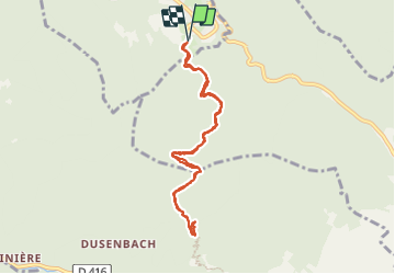

Length
8.1 km

Max alt
647 m

Uphill gradient
241 m
Km-Effort
11.3 km

Min alt
460 m

Downhill gradient
241 m
Boucle
Yes
Creation date :
2022-03-28 11:41:05.781
Updated on :
2022-03-28 15:42:49.541
3h15
Difficulty : Medium

FREE GPS app for hiking
 SityTrail
IGN / Geographical institutes
SityTrail Plus
The world is yours!
About
Trail Walking of 8.1 km to be discovered at Grand Est, Haut-Rhin, Thannenkirch. This trail is proposed by jcschubnel.
Positioning
Country:
France
Region :
Grand Est
Department/Province :
Haut-Rhin
Municipality :
Thannenkirch
Location:
Unknown
Start:(Dec)
Start:(UTM)
374084 ; 5342821 (32U) N.
Comments