


rando du 02 avril 2022

dudu79
User
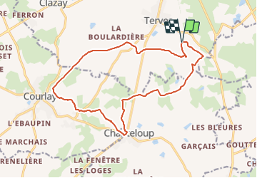

Length
16.9 km

Max alt
230 m

Uphill gradient
175 m
Km-Effort
19.2 km

Min alt
184 m

Downhill gradient
174 m
Boucle
Yes
Creation date :
2022-04-02 06:46:29.668
Updated on :
2022-04-02 16:41:09.3
4h21
Difficulty : Very difficult

FREE GPS app for hiking
 SityTrail
IGN / Geographical institutes
SityTrail Plus
The world is yours!
About
Trail Walking of 16.9 km to be discovered at New Aquitaine, Deux-Sèvres, Bressuire. This trail is proposed by dudu79.
Positioning
Country:
France
Region :
New Aquitaine
Department/Province :
Deux-Sèvres
Municipality :
Bressuire
Location:
Terves
Start:(Dec)
Start:(UTM)
690978 ; 5185679 (30T) N.
Comments