Trail Walking Saint-Ferréol - Presque le château de Montaigu - Photo

Presque le château de Montaigu

 pacal08
pacal08

User

© OpenStreetMap contributors
Length
Length
10 km
Max alt
Max alt
978 m
Uphill gradient
Uphill gradient
482 m
Km-Effort
Km-Effort  
16.4 km
Min alt
Min alt
497 m
Downhill gradient
Downhill gradient
483 m
Boucle
Boucle
Yes
Creation date :
2022-04-06 14:41:09.0
Updated on :
2022-04-06 17:00:31.354

(0 Reviews)

Walking
Walking
2h17
Difficulty : Difficult

Scan this QR Code to open this trail in the SityTrail application

FREE GPS app for hiking

Logo SityTrail SityTrail

IGN / Geographical institutes

Download SityTrail from the App Store Download SityTrail from Google Play

Logo SityTrail SityTrail World

The world is yours!

Download SityTrail from the App Store Download SityTrail from Google Play Download SityTrail on Huawei AppGallery

About

Trail Walking of 10 km to be discovered at Auvergne-Rhône-Alpes, Upper Savoy, Saint-Ferréol. This trail is proposed by pacal08.

Description

Pas eu suffisamment d’énergie pour aller jusqu’au château de Montaigu

Elevation profile

Photos

Positioning

Country:
France
Region :
Auvergne-Rhône-Alpes
Department/Province :
Upper Savoy
Municipality :
Saint-Ferréol
Location:
Unknown
Start:(UTM)
291341 ; 5070857 (32T) N.

Trails nearby

Trail Walking Faverges-Seythenex - Cret des Mouches - Photo
Walking
brichard38

Walking

Medium
(1)
Faverges-Seythenex, Auvergne-Rhône-Alpes, Upper Savoy, France
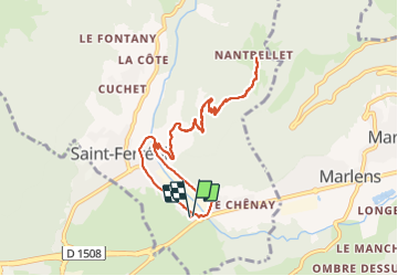
9.3 km | 22 km-effort
4h 40min
No
Trail Walking Saint-Ferréol - Crêt des Mouches 08-2019 - Photo
Walking
GUIDE
Kargil

Walking

Difficult
Saint-Ferréol, Auvergne-Rhône-Alpes, Upper Savoy, France
12.3 km | 31 km-effort
6h 48min
Yes
Trail Walking Le Bouchet-Mont-Charvin - Aulp de Marlens - Photo
Walking
flip38

Walking

Difficult
Le Bouchet-Mont-Charvin, Auvergne-Rhône-Alpes, Upper Savoy, France
17.1 km | 31 km-effort
5h 26min
Yes
Trail Walking Marthod - Dent de Cons en boucle depuis Raffort - Photo
Walking
nadd73

Walking

Medium
Marthod, Auvergne-Rhône-Alpes, Savoy, France
8.5 km | 23 km-effort
4h 21min
No
Trail Walking Faverges-Seythenex - POINTE DU VELAN - Photo
Walking
Jean-Paulchoux

Walking

Medium
Faverges-Seythenex, Auvergne-Rhône-Alpes, Upper Savoy, France
11.2 km | 24 km-effort
3h 59min
Yes
Trail Walking Faverges-Seythenex - la fosse a l'ours depuis Prafeu - Photo
Walking
COMAN

Walking

Easy
(1)
Faverges-Seythenex, Auvergne-Rhône-Alpes, Upper Savoy, France
4.7 km | 8.4 km-effort
1h 42min
Yes
Trail Walking Marthod - Le fort de la batterie - Photo
Walking
ochamley

Walking

Very easy
Marthod, Auvergne-Rhône-Alpes, Savoy, France
3.2 km | 6.9 km-effort
1h 2min
Yes
Trail Walking Faverges-Seythenex - POINTE DE VELAN bis  - Photo
Walking
Jean-Paulchoux

Walking

Difficult
Faverges-Seythenex, Auvergne-Rhône-Alpes, Upper Savoy, France
10.7 km | 23 km-effort
8h 35min
Yes
Trail Walking Saint-Ferréol - La côte de Marlens - Photo
Walking
pacal08

Walking

Medium
Saint-Ferréol, Auvergne-Rhône-Alpes, Upper Savoy, France
13.8 km | 21 km-effort
2h 50min
Yes


Close
My subscriptions