


Pointe du Drink

jcolonnadelega
User
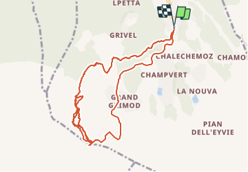

Length
11.6 km

Max alt
2622 m

Uphill gradient
1010 m
Km-Effort
25 km

Min alt
1870 m

Downhill gradient
1012 m
Boucle
Yes
Creation date :
2022-04-08 07:53:15.386
Updated on :
2022-04-11 20:59:04.659
5h24
Difficulty : Very easy

FREE GPS app for hiking
 SityTrail
IGN / Geographical institutes
SityTrail Plus
The world is yours!
About
Trail Touring skiing of 11.6 km to be discovered at Aosta Valley, Unknown, Gressan. This trail is proposed by jcolonnadelega.
Description
Val d'Aoste
Positioning
Country:
Italy
Region :
Aosta Valley
Department/Province :
Unknown
Municipality :
Gressan
Location:
Unknown
Start:(Dec)
Start:(UTM)
368406 ; 5059909 (32T) N.
Comments