


Polset - col de Chavière

laurentnecca
User
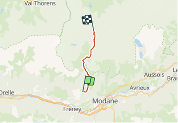

Length
9.6 km

Max alt
2790 m

Uphill gradient
1200 m
Km-Effort
22 km

Min alt
1599 m

Downhill gradient
17 m
Boucle
No
Creation date :
2022-04-11 05:21:55.842
Updated on :
2022-04-11 13:39:15.161
4h45
Difficulty : Difficult

FREE GPS app for hiking
 SityTrail
IGN / Geographical institutes
SityTrail Plus
The world is yours!
About
Trail Touring skiing of 9.6 km to be discovered at Auvergne-Rhône-Alpes, Savoy, Saint-André. This trail is proposed by laurentnecca.
Positioning
Country:
France
Region :
Auvergne-Rhône-Alpes
Department/Province :
Savoy
Municipality :
Saint-André
Location:
Unknown
Start:(Dec)
Start:(UTM)
314800 ; 5009060 (32T) N.
Comments