


les hauteurs de gueberschwihr

pascalloos
User
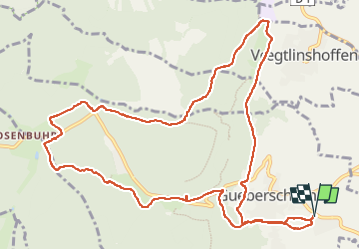

Length
13.3 km

Max alt
596 m

Uphill gradient
446 m
Km-Effort
19.3 km

Min alt
217 m

Downhill gradient
446 m
Boucle
Yes
Creation date :
2022-04-15 07:17:25.381
Updated on :
2022-04-15 10:41:47.416
3h23
Difficulty : Medium

FREE GPS app for hiking
 SityTrail
IGN / Geographical institutes
SityTrail Plus
The world is yours!
About
Trail Nordic walking of 13.3 km to be discovered at Grand Est, Haut-Rhin, Gueberschwihr. This trail is proposed by pascalloos.
Description
Gueberschwihr, st Marc, marbach, osenbuhr, marbach gueberschwihr
Positioning
Country:
France
Region :
Grand Est
Department/Province :
Haut-Rhin
Municipality :
Gueberschwihr
Location:
Unknown
Start:(Dec)
Start:(UTM)
371963 ; 5317923 (32U) N.
Comments