


montagne de la Bugla2

Tof Tof
User

Length
8.9 km

Max alt
1903 m

Uphill gradient
493 m
Km-Effort
15.5 km

Min alt
1527 m

Downhill gradient
486 m
Boucle
Yes
Creation date :
2022-04-17 10:48:51.389
Updated on :
2022-04-17 14:40:33.98
3h15
Difficulty : Medium

FREE GPS app for hiking
 SityTrail
IGN / Geographical institutes
SityTrail Plus
The world is yours!
About
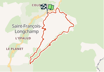
Trail Walking of 8.9 km to be discovered at Auvergne-Rhône-Alpes, Savoy, Saint-François-Longchamp. This trail is proposed by Tof Tof.
Positioning
Country:
France
Region :
Auvergne-Rhône-Alpes
Department/Province :
Savoy
Municipality :
Saint-François-Longchamp
Location:
Saint-François-Longchamp
Start:(Dec)
Start:(UTM)
293246 ; 5032441 (32T) N.
Comments