Trail On foot Saint-Genès-Champanelle - Rando Plateau de la Serre - Photo
© OpenStreetMap contributors
Length
Length
18.7 km
Max alt
Max alt
1025 m
Uphill gradient
Uphill gradient
433 m
Km-Effort
Km-Effort  
24 km
Min alt
Min alt
832 m
Downhill gradient
Downhill gradient
435 m
Boucle
Boucle
Yes
Creation date :
2022-04-17 12:16:13.06
Updated on :
2022-04-17 17:56:12.128

(0 Reviews)

On foot
On foot
5h33
Difficulty : Medium
Walking
Walking
3h10
Difficulty : Very difficult
Mountain bike
Mountain bike
1h41
Difficulty : Medium

Scan this QR Code to open this trail in the SityTrail application

FREE GPS app for hiking

Logo SityTrail SityTrail

IGN / Geographical institutes

Download SityTrail from the App Store Download SityTrail from Google Play

Logo SityTrail SityTrail World

The world is yours!

Download SityTrail from the App Store Download SityTrail from Google Play Download SityTrail on Huawei AppGallery

About

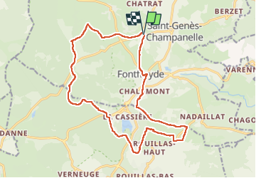
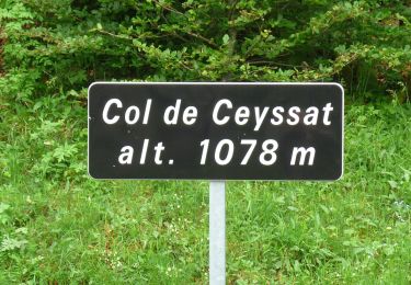
Trail On foot of 18.7 km to be discovered at Auvergne-Rhône-Alpes, Puy-de-Dôme, Saint-Genès-Champanelle. This trail is proposed by PsyPezman.

Description

Attention nous l'avons fait à vitesse rapide ;-) Comptez plutôt 5h à vitesse tranquille.

Elevation profile

Photos

Positioning

Country:
France
Region :
Auvergne-Rhône-Alpes
Department/Province :
Puy-de-Dôme
Municipality :
Saint-Genès-Champanelle
Location:
Unknown
Start:(UTM)
500440 ; 5062727 (31T) N.

Trails nearby

Trail Walking Ceyrat - Ceyrat_Tour_Montrognon - Photo
Walking
GUIDE
jagarnier

Walking

Easy
(1)
Ceyrat, Auvergne-Rhône-Alpes, Puy-de-Dôme, France
7.2 km | 9.3 km-effort
2h 15min
Yes
Trail Walking Aydat - Lassolas-La Vache-Vichatel - Photo
Walking
pidjam

Walking

Medium
(1)
Aydat, Auvergne-Rhône-Alpes, Puy-de-Dôme, France
13.2 km | 18.6 km-effort
4h 4min
Yes
Trail Walking Royat - Oclede-GraveNoire-Charade_T - Photo
Walking
force

Walking

Medium
(1)
Royat, Auvergne-Rhône-Alpes, Puy-de-Dôme, France
10.3 km | 15.9 km-effort
1h 36min
Yes
Trail Walking Aydat - puy de Vichatel - Photo
Walking
bernardeau

Walking

Very easy
(1)
Aydat, Auvergne-Rhône-Alpes, Puy-de-Dôme, France
3.8 km | 5.8 km-effort
1h 13min
Yes
Trail On foot Aydat - Les Cheires Hautes - Photo
On foot
PRO

On foot

Easy
Aydat, Auvergne-Rhône-Alpes, Puy-de-Dôme, France
15.9 km | 20 km-effort
4h 32min
Yes
Trail On foot Aydat - Le Lac de la Cassière - Photo
On foot
PRO

On foot

Easy
Aydat, Auvergne-Rhône-Alpes, Puy-de-Dôme, France
3.2 km | 4 km-effort
54min
Yes
Trail On foot Saint-Genès-Champanelle - Nadaillat - Photo
On foot
PRO

On foot

Easy
Saint-Genès-Champanelle, Auvergne-Rhône-Alpes, Puy-de-Dôme, France
6.6 km | 9.3 km-effort
2h 7min
Yes
Trail On foot Aydat - Le Puy de Vichatel - Photo
On foot
PRO

On foot

Easy
Aydat, Auvergne-Rhône-Alpes, Puy-de-Dôme, France
8.1 km | 10.5 km-effort
2h 22min
Yes
Trail On foot Saint-Genès-Champanelle - Mazaye / Laschamp - Photo
On foot
PRO

On foot

Medium
Saint-Genès-Champanelle, Auvergne-Rhône-Alpes, Puy-de-Dôme, France
21 km | 30 km-effort
6h 46min
No


Close
My subscriptions