Trail Walking Flavignerot - La roche Pompon  - Photo
 Annie21
Annie21

User

© OpenStreetMap contributors
Length
Length
15.3 km
Max alt
Max alt
585 m
Uphill gradient
Uphill gradient
611 m
Km-Effort
Km-Effort  
23 km
Min alt
Min alt
343 m
Downhill gradient
Downhill gradient
610 m
Boucle
Boucle
Yes
Creation date :
2022-04-21 08:03:38.368
Updated on :
2022-04-21 16:30:18.513

(0 Reviews)

Walking
Walking
5h00
Difficulty : Medium

Scan this QR Code to open this trail in the SityTrail application

FREE GPS app for hiking

Logo SityTrail SityTrail

IGN / Geographical institutes

Download SityTrail from the App Store Download SityTrail from Google Play

Logo SityTrail SityTrail World

The world is yours!

Download SityTrail from the App Store Download SityTrail from Google Play Download SityTrail on Huawei AppGallery

About

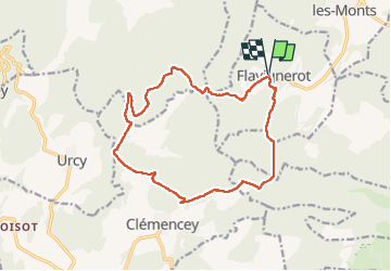
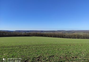
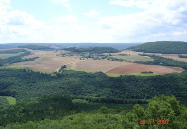
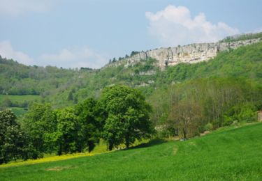
Trail Walking of 15.3 km to be discovered at Bourgogne-Franche-Comté, Côte-d'Or, Flavignerot. This trail is proposed by Annie21.

Description

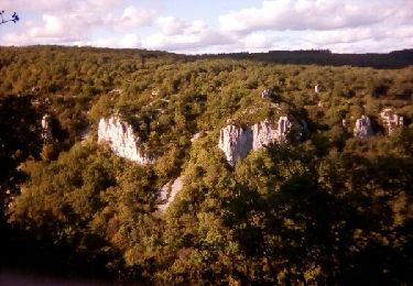
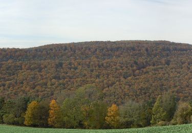
Rando agréable, pas de difficulté, super vue depuis la roche   Rente des Ecotois   Rente de Chamerey.
Départ Flavignerot,

Elevation profile

Photos

Positioning

Country:
France
Region :
Bourgogne-Franche-Comté
Department/Province :
Côte-d'Or
Municipality :
Flavignerot
Location:
Unknown
Start:(UTM)
644945 ; 5237945 (31T) N.

Trails nearby

Trail Walking Marsannay-la-Côte - Marsannay  la Côte 2021-03-02 repérage CAF - Photo
Walking
TRIMAILLE

Walking

Very easy
(1)
Marsannay-la-Côte, Bourgogne-Franche-Comté, Côte-d'Or, France
23 km | 30 km-effort
4h 39min
Yes
Trail Walking Brochon - falaises et plateau - Photo
Walking
mpstoop

Walking

Difficult
(1)
Brochon, Bourgogne-Franche-Comté, Côte-d'Or, France
15.9 km | 22 km-effort
4h 45min
No
Trail Walking Velars-sur-Ouche - velars - Photo
Walking
hueco

Walking

Medium
(1)
Velars-sur-Ouche, Bourgogne-Franche-Comté, Côte-d'Or, France
13.5 km | 19.2 km-effort
3h 30min
Yes
Trail Walking Urcy - Les environs d'Urcy - Photo
Walking
tracegps

Walking

Difficult
(2)
Urcy, Bourgogne-Franche-Comté, Côte-d'Or, France
18.9 km | 27 km-effort
6h 0min
No
Trail Walking Velars-sur-Ouche - Parcours Jean Sage - Velars sur Ouche - Photo
Walking
tracegps

Walking

Difficult
(1)
Velars-sur-Ouche, Bourgogne-Franche-Comté, Côte-d'Or, France
26 km | 45 km-effort
8h 0min
No
Trail Walking Fleurey-sur-Ouche - Le Marathon de Fleurey sur Ouche - Photo
Walking
tracegps

Walking

Very difficult
(1)
Fleurey-sur-Ouche, Bourgogne-Franche-Comté, Côte-d'Or, France
40 km | 54 km-effort
10h 0min
Yes
Trail On foot Corcelles-les-Monts - Circuit découverte des Cadoles - Photo
On foot
PRO

On foot

Easy
Corcelles-les-Monts, Bourgogne-Franche-Comté, Côte-d'Or, France
3.3 km | 4 km-effort
53min
Yes
Trail On foot Dijon - Circuit Découverte des Hauts de la Combe - Photo
On foot
PRO

On foot

Easy
Dijon, Bourgogne-Franche-Comté, Côte-d'Or, France
4.2 km | 5.4 km-effort
1h 13min
Yes
Trail On foot Flavignerot - Du Naizou au Mont Afrique - Photo
On foot
PRO

On foot

Easy
Flavignerot, Bourgogne-Franche-Comté, Côte-d'Or, France
8.9 km | 11.4 km-effort
2h 35min
Yes


Close
My subscriptions