Trail Walking Montbouy - Montbouy - Photo
© OpenStreetMap contributors
Length
Length
11.6 km
Max alt
Max alt
137 m
Uphill gradient
Uphill gradient
93 m
Km-Effort
Km-Effort  
12.9 km
Min alt
Min alt
104 m
Downhill gradient
Downhill gradient
93 m
Boucle
Boucle
Yes
Creation date :
2022-04-24 06:01:24.29
Updated on :
2022-08-11 16:20:19.43

(0 Reviews)

Walking
Walking
2h44
Difficulty : Very easy

Scan this QR Code to open this trail in the SityTrail application

FREE GPS app for hiking

Logo SityTrail SityTrail

IGN / Geographical institutes

Download SityTrail from the App Store Download SityTrail from Google Play

Logo SityTrail SityTrail World

The world is yours!

Download SityTrail from the App Store Download SityTrail from Google Play Download SityTrail on Huawei AppGallery

About

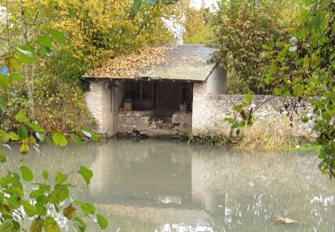
Trail Walking of 11.6 km to be discovered at Centre-Loire Valley, Loiret, Montbouy. This trail is proposed by Ordijamo45.

Description

Départ du camping

Elevation profile

Positioning

Country:
France
Region :
Centre-Loire Valley
Department/Province :
Loiret
Municipality :
Montbouy
Location:
Unknown
Start:(UTM)
486761 ; 5300943 (31T) N.

Trails nearby

Trail Walking Montbouy - Montbouy 45 rando  - Photo
Walking
picouleau220345

Walking

Difficult
Montbouy, Centre-Loire Valley, Loiret, France
14.8 km | 16.3 km-effort
2h 54min
Yes
Trail Walking Montcresson - L'orme au Muet - Photo
Walking
Ordijamo45

Walking

Easy
Montcresson, Centre-Loire Valley, Loiret, France
11.2 km | 12.3 km-effort
1h 52min
Yes
Trail Walking Sainte-Geneviève-des-Bois - chatillon coligny dammarie lez perrault 15 km - Photo
Walking
picouleau220345

Walking

Medium
Sainte-Geneviève-des-Bois, Centre-Loire Valley, Loiret, France
15.1 km | 16.6 km-effort
3h 1min
Yes
Trail Walking Montcresson - montcresson 45 - Photo
Walking
picouleau220345

Walking

Difficult
Montcresson, Centre-Loire Valley, Loiret, France
11.9 km | 13.5 km-effort
3h 2min
No
Trail Walking Nogent-sur-Vernisson - les Barres 45 Nogent sur Vernisson - Photo
Walking
picouleau220345

Walking

Medium
Nogent-sur-Vernisson, Centre-Loire Valley, Loiret, France
10.4 km | 11.8 km-effort
2h 17min
No
Trail Walking Châtillon-Coligny - Chatillon-Coligny 45 P.G - Photo
Walking
picouleau220345

Walking

Medium
Châtillon-Coligny, Centre-Loire Valley, Loiret, France
11.5 km | 12.7 km-effort
3h 4min
Yes
Trail Walking Montbouy - Montbouy 45 G - Photo
Walking
picouleau220345

Walking

Difficult
Montbouy, Centre-Loire Valley, Loiret, France
13.3 km | 14.8 km-effort
3h 3min
Yes
Trail Walking Montcresson - Pr de la vallée du Loing - Photo
Walking
Ordijamo45

Walking

Easy
Montcresson, Centre-Loire Valley, Loiret, France
13.2 km | 14.3 km-effort
3h 10min
Yes
Trail Walking Sainte-Geneviève-des-Bois - Chatillon Coligny les Remparts du chateau - Photo
Walking
picouleau220345

Walking

Easy
Sainte-Geneviève-des-Bois, Centre-Loire Valley, Loiret, France
9.5 km | 10.6 km-effort
1h 50min
Yes


Close
My subscriptions