


sentier littoral port vendre banyuls

elexine23
User
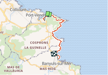

Length
10.8 km

Max alt
120 m

Uphill gradient
300 m
Km-Effort
14.8 km

Min alt
0 m

Downhill gradient
303 m
Boucle
No
Creation date :
2022-04-26 06:49:01.64
Updated on :
2022-04-26 12:22:31.426
3h22
Difficulty : Easy

FREE GPS app for hiking
 SityTrail
IGN / Geographical institutes
SityTrail Plus
The world is yours!
About
Trail Walking of 10.8 km to be discovered at Occitania, Pyrénées-Orientales, Port-Vendres. This trail is proposed by elexine23.
Positioning
Country:
France
Region :
Occitania
Department/Province :
Pyrénées-Orientales
Municipality :
Port-Vendres
Location:
Unknown
Start:(Dec)
Start:(UTM)
509354 ; 4707019 (31T) N.
Comments