Trail Walking Cipières - Cipieres : le grand Pounch - Photo
 ETMU5496
ETMU5496

User

© OpenStreetMap contributors
Length
Length
21 km
Max alt
Max alt
1265 m
Uphill gradient
Uphill gradient
860 m
Km-Effort
Km-Effort  
33 km
Min alt
Min alt
575 m
Downhill gradient
Downhill gradient
860 m
Boucle
Boucle
Yes
Creation date :
2022-04-27 06:21:51.0
Updated on :
2022-05-02 16:23:48.254

(0 Reviews)

Walking
Walking
5h58
Difficulty : Difficult

Scan this QR Code to open this trail in the SityTrail application

FREE GPS app for hiking

Logo SityTrail SityTrail

IGN / Geographical institutes

Download SityTrail from the App Store Download SityTrail from Google Play

Logo SityTrail SityTrail World

The world is yours!

Download SityTrail from the App Store Download SityTrail from Google Play Download SityTrail on Huawei AppGallery

About

Trail Walking of 21 km to be discovered at Provence-Alpes-Côte d'Azur, Maritime Alps, Cipières. This trail is proposed by ETMU5496.

Description

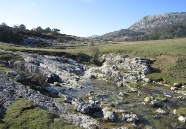
L'orientation au cours de la traversée du massif du grand Pounch n'est pas toujours aisée.

Elevation profile

Photos

Positioning

Country:
France
Region :
Provence-Alpes-Côte d'Azur
Department/Province :
Maritime Alps
Municipality :
Cipières
Location:
Unknown
Start:(Dec)
Start:(UTM)
335357 ; 4849745 (32T) N.

Trails nearby

Trail Walking Caussols - Le Haut Montet 1335m, Plateau de Caussols - Photo
Walking
tracegps

Walking

Easy
(1)
Caussols, Provence-Alpes-Côte d'Azur, Maritime Alps, France
13.5 km | 18.6 km-effort
4h 0min
Yes
Trail On foot Caussols - Plateau de Caussols - Photo
On foot
PRO

On foot

Easy
Caussols, Provence-Alpes-Côte d'Azur, Maritime Alps, France
13.9 km | 19.1 km-effort
4h 20min
Yes
Trail On foot Cipières - Traversée de l'Estéron - Etape 2 - Photo
On foot
PRO

On foot

Difficult
Cipières, Provence-Alpes-Côte d'Azur, Maritime Alps, France
21 km | 41 km-effort
9h 18min
No
Trail On foot Cipières - Traversée de l'Estéron - Etape 1 - Photo
On foot
PRO

On foot

Medium
Cipières, Provence-Alpes-Côte d'Azur, Maritime Alps, France
18.4 km | 29 km-effort
6h 28min
No
Trail On foot Gréolières - Cime du Cheiron - Photo
On foot
PRO

On foot

Easy
Gréolières, Provence-Alpes-Côte d'Azur, Maritime Alps, France
5.9 km | 8.9 km-effort
2h 1min
No
Trail On foot Cipières - Plateau de Calern - Photo
On foot
PRO

On foot

Medium
Cipières, Provence-Alpes-Côte d'Azur, Maritime Alps, France
13.5 km | 21 km-effort
4h 44min
Yes
Trail On foot Gréolières - Circuit du Loup - Photo
On foot
PRO

On foot

Easy
Gréolières, Provence-Alpes-Côte d'Azur, Maritime Alps, France
6.5 km | 12.7 km-effort
2h 52min
Yes
Trail On foot Gréolières - Traversée des Miroirs - Photo
On foot
PRO

On foot

Easy
Gréolières, Provence-Alpes-Côte d'Azur, Maritime Alps, France
6.6 km | 12 km-effort
2h 43min
No
Trail On foot Courmes - Plateau de Saint-Barnabé - Photo
On foot
PRO

On foot

Easy
Courmes, Provence-Alpes-Côte d'Azur, Maritime Alps, France
6.6 km | 11.1 km-effort
2h 31min
Yes


Close
My subscriptions