


La Bouille / Vraie Côte

GR5 2020
User
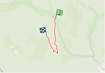

Length
1.4 km

Max alt
609 m

Uphill gradient
137 m
Km-Effort
2.7 km

Min alt
464 m

Downhill gradient
0 m
Boucle
No
Creation date :
2022-05-04 06:48:23.865
Updated on :
2022-05-04 07:21:46.575
29m
Difficulty : Medium

FREE GPS app for hiking
 SityTrail
IGN / Geographical institutes
SityTrail Plus
The world is yours!
About
Trail Walking of 1.4 km to be discovered at Grand Est, Haut-Rhin, Sainte-Croix-aux-Mines. This trail is proposed by GR5 2020.
Description
nouveau sentier
Positioning
Country:
France
Region :
Grand Est
Department/Province :
Haut-Rhin
Municipality :
Sainte-Croix-aux-Mines
Location:
Unknown
Start:(Dec)
Start:(UTM)
365504 ; 5348358 (32U) N.
Comments