


Guebwiller Osenbach

duchaine.nicolas
User
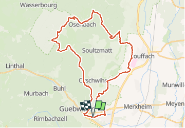

Length
41 km

Max alt
585 m

Uphill gradient
945 m
Km-Effort
53 km

Min alt
207 m

Downhill gradient
943 m
Boucle
Yes
Creation date :
2022-05-07 13:28:37.858
Updated on :
2022-05-07 19:11:53.974
3h16
Difficulty : Easy
3h16
Difficulty : Easy

FREE GPS app for hiking
 SityTrail
IGN / Geographical institutes
SityTrail Plus
The world is yours!
About
Trail Mountain bike of 41 km to be discovered at Grand Est, Haut-Rhin, Guebwiller. This trail is proposed by duchaine.nicolas.
Positioning
Country:
France
Region :
Grand Est
Department/Province :
Haut-Rhin
Municipality :
Guebwiller
Location:
Unknown
Start:(Dec)
Start:(UTM)
367982 ; 5306924 (32T) N.
Comments