


05 Aix - TraceGps issued

houbart
User
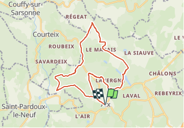

Length
17.2 km

Max alt
877 m

Uphill gradient
412 m
Km-Effort
23 km

Min alt
742 m

Downhill gradient
412 m
Boucle
Yes
Creation date :
2022-05-08 13:31:08.2
Updated on :
2022-05-08 13:32:32.401
5h09
Difficulty : Very difficult

FREE GPS app for hiking
 SityTrail
IGN / Geographical institutes
SityTrail Plus
The world is yours!
About
Trail Walking of 17.2 km to be discovered at New Aquitaine, Corrèze, Aix. This trail is proposed by houbart.
Positioning
Country:
France
Region :
New Aquitaine
Department/Province :
Corrèze
Municipality :
Aix
Location:
Unknown
Start:(Dec)
Start:(UTM)
451870 ; 5051541 (31T) N.
Comments