Trail Walking Jouy-en-Josas - Tracé actuel: 08 MAI 2022 08:55 - Photo

Tracé actuel: 08 MAI 2022 08:55

© OpenStreetMap contributors
Length
Length
11.7 km
Max alt
Max alt
156 m
Uphill gradient
Uphill gradient
219 m
Km-Effort
Km-Effort  
14.7 km
Min alt
Min alt
87 m
Downhill gradient
Downhill gradient
219 m
Boucle
Boucle
Yes
Creation date :
2022-05-09 07:55:42.446
Updated on :
2022-05-09 08:04:57.3

(0 Reviews)

Walking
Walking
3h20
Difficulty : Difficult

Scan this QR Code to open this trail in the SityTrail application

FREE GPS app for hiking

Logo SityTrail SityTrail

IGN / Geographical institutes

Download SityTrail from the App Store Download SityTrail from Google Play

Logo SityTrail SityTrail World

The world is yours!

Download SityTrail from the App Store Download SityTrail from Google Play Download SityTrail on Huawei AppGallery

About

Trail Walking of 11.7 km to be discovered at Ile-de-France, Yvelines, Jouy-en-Josas. This trail is proposed by JacquesMARQUET.

Description

Une randonnée agréable et sportive.
A faire par beau temps et prendre son temps à la ferme de Viltain.

Elevation profile

Positioning

Country:
France
Region :
Ile-de-France
Department/Province :
Yvelines
Municipality :
Jouy-en-Josas
Location:
Unknown
Start:(UTM)
438083 ; 5400406 (31U) N.

Trails nearby

Trail Walking Bièvres - De Bièvres à Antony - Photo
Walking
tracegps

Walking

Medium
(1)
Bièvres, Ile-de-France, Essonne, France
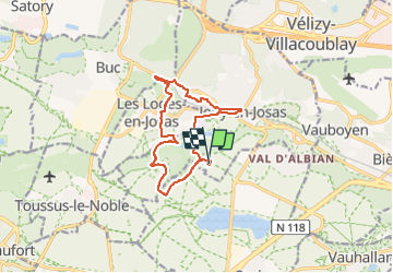
11.9 km | 14 km-effort
3h 0min
No
Trail Walking Châteaufort - gitane à  Chateaufort  - Photo
Walking
philou91

Walking

Easy
(1)
Châteaufort, Ile-de-France, Yvelines, France
6.4 km | 7.7 km-effort
2h 3min
Yes
Trail Walking Jouy-en-Josas - ferme viltain - Photo
Walking
papoune69

Walking

Very easy
(2)
Jouy-en-Josas, Ile-de-France, Yvelines, France
9 km | 10.1 km-effort
2h 13min
Yes
Trail Walking Buc - Le Tour de Satory - Photo
Walking
tracegps

Walking

Difficult
(2)
Buc, Ile-de-France, Yvelines, France
23 km | 28 km-effort
4h 49min
Yes
Trail Walking Bièvres - Autour de Bièvres - Photo
Walking
tracegps

Walking

Medium
(4)
Bièvres, Ile-de-France, Essonne, France
7.6 km | 9.4 km-effort
2h 30min
Yes
Trail On foot Orsay - FR-2 - Photo
On foot
PRO

On foot

Easy
Orsay, Ile-de-France, Essonne, France
4 km | 5.3 km-effort
1h 12min
No
Trail Walking Guyancourt - ALBG Etang val d'or, minière - Photo
Walking
IreneProvost

Walking

Easy
(1)
Guyancourt, Ile-de-France, Yvelines, France
13.1 km | 16.1 km-effort
3h 41min
Yes
Trail Walking Châteaufort - circuit orange - Photo
Walking
schmittclaudine

Walking

Very easy
(1)
Châteaufort, Ile-de-France, Yvelines, France
5.5 km | 7.1 km-effort
1h 22min
Yes
Trail Walking Châteaufort - Circuit vert - Photo
Walking
schmittclaudine

Walking

Very easy
(1)
Châteaufort, Ile-de-France, Yvelines, France
5.8 km | 6.8 km-effort
1h 15min
Yes


Close
My subscriptions