


Tour des 4 lacs

philvor
User
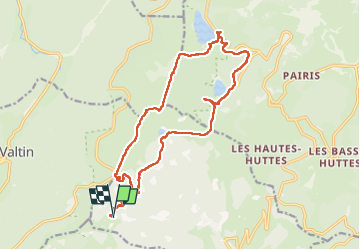

Length
18.1 km

Max alt
1304 m

Uphill gradient
702 m
Km-Effort
27 km

Min alt
948 m

Downhill gradient
709 m
Boucle
Yes
Creation date :
2022-05-11 07:15:20.0
Updated on :
2022-05-11 19:53:55.756
8h30
Difficulty : Very difficult

FREE GPS app for hiking
 SityTrail
IGN / Geographical institutes
SityTrail Plus
The world is yours!
About
Trail Walking of 18.1 km to be discovered at Grand Est, Haut-Rhin, Soultzeren. This trail is proposed by philvor.
Description
Tour des 4 lacs
Positioning
Country:
France
Region :
Grand Est
Department/Province :
Haut-Rhin
Municipality :
Soultzeren
Location:
Unknown
Start:(Dec)
Start:(UTM)
355515 ; 5327396 (32U) N.
Comments