![](/images/other/stat-length.png)
![Trail Walking Pepinster - 2022-05-13_11h44m22_Cirkwi-Soiron_6___Tribomont,_Wegnez - Photo](https://media.geolcdn.com/t/1900/400/ext.pjpeg?maxdim=2&url=https%3A%2F%2Fmedia.geolcdn.com%2Ff%2Fec8c930a-9871-4566-956d-2a2016034199.jpg)
2022-05-13_11h44m22_Cirkwi-Soiron_6___Tribomont,_Wegnez
mumu.larandonneuse
User GUIDE
![Length](/images/other/stat-length.png)
Length
9.5 km
![Max alt](https://static1.geolcdn.com/siteimages/upload/files/1508320355ic_sort_altitude_max_24dp.png)
Max alt
273 m
![Uphill gradient](https://static1.geolcdn.com/siteimages/upload/files/1508320355ic_sort_den_pos_24dp.png)
Uphill gradient
222 m
![Km-Effort](/images/other/stat-length.png)
Km-Effort
12.5 km
![Min alt](https://static1.geolcdn.com/siteimages/upload/files/1508320355ic_sort_altitude_min_24dp.png)
Min alt
196 m
![Downhill gradient](https://static1.geolcdn.com/siteimages/upload/files/1508320355ic_sort_den_neg_24dp.png)
Downhill gradient
225 m
![Boucle](https://static1.geolcdn.com/siteimages/upload/files/16400158638029165_repeat_loop_refresh_sync_direction_icon.png)
Boucle
Yes
Creation date :
2022-05-13 09:44:22.351
Updated on :
2023-02-28 18:53:48.525
![Walking](https://static1.geolcdn.com/sitytour/trail-icons/101.png)
2h50
Difficulty : Easy
![Scan this QR Code to open this trail in the SityTrail application](https://capi.geolives.com/qq0zvz2zws4bq2lad0pu/sitytour/trails/3240394/qr.png?size=200)
FREE GPS app for hiking
About
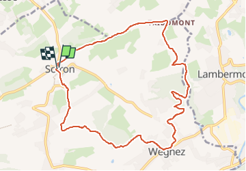
Trail Walking of 9.5 km to be discovered at Wallonia, Liège, Pepinster. This trail is proposed by mumu.larandonneuse.
Description
Départ de Soiron (un des Plus Beaux Villages de Wallonie) en direction du bas de Tribomont par le chemin réhabilité, le Nauzaury. Passage par la réserve domaniale de Tribomont et retour par le village de Wegnez et les doux fonds à Soiron. Suivre balisage "Rectangle vert 2".
Positioning
Country:
Belgium
Region :
Wallonia
Department/Province :
Liège
Municipality :
Pepinster
Location:
Unknown
Start:(Dec)
Start:(UTM)
697496 ; 5608212 (31U) N.
Comments
Trails nearby
![Trail Walking Pepinster - RB-Lg-23_Soiron_via-racc-2 - Photo](https://media.geolcdn.com/t/375/260/ext.jpg?maxdim=2&url=https%3A%2F%2Fservices.sitytrail.com%2FGeolivesWS%2FDownloadMedia.ashx%3FTrailID%3D400856%26Media%3D1646b7fd-8650-448d-bc3d-5efa9ed8c932.jpg)
![Walking Walking](https://static1.geolcdn.com/sitytour/trail-icons/101.png)
RB-Lg-23_Soiron_via-racc-2
Walking
(7)
Pepinster,
Wallonia,
Liège,
Belgium
![](/images/other/stat-length.png)
13.4 km | 17.5 km-effort
3h 58min
![](https://static1.geolcdn.com/siteimages/upload/files/16400158638029165_repeat_loop_refresh_sync_direction_icon.png)
Yes
![Trail Walking Pepinster - RB-Lg-23_Soiron - Photo](https://media.geolcdn.com/t/375/260/ext.jpg?maxdim=2&url=https%3A%2F%2Fservices.sitytrail.com%2FGeolivesWS%2FDownloadMedia.ashx%3FTrailID%3D400853%26Media%3D1646b7fd-8650-448d-bc3d-5efa9ed8c932.jpg)
![Walking Walking](https://static1.geolcdn.com/sitytour/trail-icons/101.png)
![Trail Walking Trooz - RB-Lg-03 - Entre Vesdre et Hoëgne - Photo](https://media.geolcdn.com/t/375/260/ext.jpg?maxdim=2&url=https%3A%2F%2Fservices.sitytrail.com%2FGeolivesWS%2FDownloadMedia.ashx%3FTrailID%3D179559%26Media%3Dcef2de81-7d4f-4fcd-9e9d-f315370fe61f.jpg)
![Walking Walking](https://static1.geolcdn.com/sitytour/trail-icons/101.png)
RB-Lg-03 - Entre Vesdre et Hoëgne
Walking
Medium
(12)
Trooz,
Wallonia,
Liège,
Belgium
![](/images/other/stat-length.png)
22 km | 29 km-effort
6h 9min
![](https://static1.geolcdn.com/siteimages/upload/files/16400158638029165_repeat_loop_refresh_sync_direction_icon.png)
Yes
![Trail Walking Olne - 20220307 - Saint-Hadelin 8.8 Km - Photo](https://media.geolcdn.com/t/375/260/ext.jpg?maxdim=2&url=https%3A%2F%2Fmedia.geolcdn.com%2Ff%2F43e602b0-affa-474f-b900-92064e4a884a.JPG)
![Walking Walking](https://static1.geolcdn.com/sitytour/trail-icons/101.png)
20220307 - Saint-Hadelin 8.8 Km
Walking
Medium
(1)
Olne,
Wallonia,
Liège,
Belgium
![](/images/other/stat-length.png)
8.4 km | 10.9 km-effort
2h 24min
![](https://static1.geolcdn.com/siteimages/upload/files/16400158638029165_repeat_loop_refresh_sync_direction_icon.png)
Yes
![Trail Walking Trooz - 2022-02-03_17h57m35_BaladedeFraipont - Photo](https://media.geolcdn.com/t/375/260/ext.jpg?maxdim=2&url=https%3A%2F%2Fmedia.geolcdn.com%2Ff%2Fa22be754-a7d6-4ac7-b88b-6e30a6735908.jpg)
![Walking Walking](https://static1.geolcdn.com/sitytour/trail-icons/101.png)
2022-02-03_17h57m35_BaladedeFraipont
Walking
Medium
(1)
Trooz,
Wallonia,
Liège,
Belgium
![](/images/other/stat-length.png)
12.3 km | 17.3 km-effort
3h 55min
![](https://static1.geolcdn.com/siteimages/upload/files/16400158638029165_repeat_loop_refresh_sync_direction_icon.png)
Yes
![Trail Walking Olne - 2021-03-10_16h10m11_1409 - Photo](https://media.geolcdn.com/t/375/260/ext.jpg?maxdim=2&url=https%3A%2F%2Fmedia.geolcdn.com%2Ff%2F8c16a020-3972-4fd4-95a4-e68b814bf4ee.jpg)
![Walking Walking](https://static1.geolcdn.com/sitytour/trail-icons/101.png)
2021-03-10_16h10m11_1409
Walking
Medium
(3)
Olne,
Wallonia,
Liège,
Belgium
![](/images/other/stat-length.png)
11.7 km | 16.1 km-effort
3h 39min
![](https://static1.geolcdn.com/siteimages/upload/files/16400158638029165_repeat_loop_refresh_sync_direction_icon.png)
Yes
![Trail Walking Olne - 20210208 - Olne 9 Km - Photo](https://media.geolcdn.com/t/375/260/ext.jpg?maxdim=2&url=https%3A%2F%2Fmedia.geolcdn.com%2Ff%2F96572363-611a-4c92-834f-535e5815a736.JPG)
![Walking Walking](https://static1.geolcdn.com/sitytour/trail-icons/101.png)
20210208 - Olne 9 Km
Walking
Medium
(3)
Olne,
Wallonia,
Liège,
Belgium
![](/images/other/stat-length.png)
9.1 km | 12.4 km-effort
2h 31min
![](https://static1.geolcdn.com/siteimages/upload/files/16400158638029165_repeat_loop_refresh_sync_direction_icon.png)
Yes
![Trail Walking Herve - 20210214 - Bruyères 5 Km - Photo](https://media.geolcdn.com/t/375/260/ext.jpg?maxdim=2&url=https%3A%2F%2Fmedia.geolcdn.com%2Ff%2Fff3f0db1-1bfd-42f0-aaa1-ea50f26d3f61.JPG)
![Walking Walking](https://static1.geolcdn.com/sitytour/trail-icons/101.png)
20210214 - Bruyères 5 Km
Walking
Easy
(1)
Herve,
Wallonia,
Liège,
Belgium
![](/images/other/stat-length.png)
5.3 km | 6.6 km-effort
1h 41min
![](https://static1.geolcdn.com/siteimages/upload/files/16400158638029165_repeat_loop_refresh_sync_direction_icon.png)
Yes
![Trail Walking Olne - Les bocages du Rafhay: Olne - Saint Hadelin - Photo](https://media.geolcdn.com/t/375/260/ext.jpg?maxdim=2&url=https%3A%2F%2Fmedia.geolcdn.com%2Ff%2F36ef1358-6601-4f89-b979-87280e1d3acc.JPG)
![Walking Walking](https://static1.geolcdn.com/sitytour/trail-icons/101.png)
Les bocages du Rafhay: Olne - Saint Hadelin
Walking
Medium
(4)
Olne,
Wallonia,
Liège,
Belgium
![](/images/other/stat-length.png)
7 km | 8.9 km-effort
2h 0min
![](https://static1.geolcdn.com/siteimages/upload/files/16400158638029165_repeat_loop_refresh_sync_direction_icon.png)
Yes
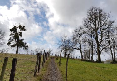
Superbe balade campagnarde et boisée. Faite avec Luna 🐕.